
Grand Ballon-west
CyclingUp: Grand Ballon-west
Climbing effort: 806 cep
Elevation meters: 952
Steepest kilometer: 11.8%
Steepest 250 m: 14%
Foot: 391 m Top: 1341 m
Mean slope: 7.5%
Length: 12.6 km
From: Moosch
Road conditions (2021): good
Other race bikers: 1-5 per hour
Motor vehicles: <10 per hour
Scenery and road:
Restaurant or bar near top: yes
PHOTOS
NE SW SE E NW SIDE Download gpx
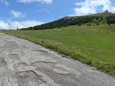

In 2021, when I cycled from Moosch to the Grand Ballon,
the road surface of part of this climb
(between Geishouse and the Col du Haag) was horrible.
Two years later, this "road" was replaced by a fabulous cycle path,
forbidden for motorized traffic.
Since that cycle path is also quite steep in parts,
it is great for real climbers.
The first five kilometers of the ride, until Geishouse,
are not steep (mostly 7%).
However, after turning sharply right at the top of this village,
the road becomes steeper.
Soon you cycle onto the bicycle path.
First there are two kilometers with an average gradient of 8.9%.
The next 2.5 kilometers have a steep middle section
with easy sections at their beginning and end.
The last one ends in a hairpin bend to the left,
after which the hardest passage begins
(1.6 kilometers with an average of 11.1%).
This passage includes a 250-metre stretch of 14%
shortly before its end and then finishes at the Col du Haag,
where the cycle path reaches the Route des Crêtes.
Another 1400 metres (7-9%) must then be covered
on the Route des Crêtes, until the highest point of this road
not far from the Grand Ballon.
Rijd op 21 maart deze prachtige tocht vanuit Wageningen over de Veluwe. Keuze uit 80 en 125 km met resp. 580 en 990 hoogtemeters. Inschrijving vanaf 31 december
Tour for Life
Rijdt deze zomer de unieke en klassieke 8-daagse wielrentocht van Noord-Italië naar Zuid-Nederland voor Artsen zonder Grenzen!