
Grand Ballon-east
CyclingUp: Grand Ballon-east
Climbing effort: 721 cep
Elevation meters: 1053
Steepest kilometer: 9.8%
Steepest 250 m: 12%
Foot: 297 m Top: 1341 m
Mean slope: 5.9%
Length: 17.6 km
From: Soultz-Haut-Rhin
Road conditions (2021): good
Other race bikers: >25 per hour
Motor vehicles: 30-60 per hour
Scenery and road:
Restaurant or bar near top: yes
PHOTOS
W SW SE NE NW SIDE Download gpx

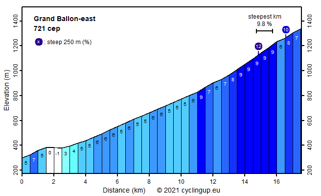
This trip from Soultz-Haut-Rhin to the Grand Ballon is my favorite climb on this mountain. It consists of two parts, which have a very different profile and are separated by the Col Amic. The part before the Col Amic is 11 kilometers long and looks almost like specially built for cyclists. The rather narrow road winds uphill with many bends and has an almost perfect asphalt surface. Whereas motorized traffic was almost absent, I saw a lot of cyclists. Climbing is relatively easy, as the road almost always slopes 5-6%. Unfortunately the view consists only of trees. The second part of the climb is considerably steeper. The route between the Col Amic and the Grand Ballon is 6.5 kilometers long with an average slope of 8.0% and a steepest kilometer of 9.7%. First the surroundings consist of dense forests but during the final 3 kilometers these give way to the more open landscape of the highest parts of the Vosges, allowing wide views. The finish is some 80 meters below the highest point of the Vosges (1424 m).
Rijd op 21 maart deze prachtige tocht vanuit Wageningen over de Veluwe. Keuze uit 80 en 125 km met resp. 580 en 990 hoogtemeters. Inschrijving vanaf 31 december
Tour for Life
Rijdt deze zomer de unieke en klassieke 8-daagse wielrentocht van Noord-Italië naar Zuid-Nederland voor Artsen zonder Grenzen!