
Brocken
CyclingUp: Brocken
Climbing effort: 445 cep
Elevation meters: 682
Steepest kilometer: 9.4%
Steepest 250 m: 11%
Foot: 490 m Top: 1148 m
Mean slope: 4.4%
Length: 14.8 km
From: Elend
Road conditions (2013): excellent
Other race bikers: 5-10 per hour
Motor vehicles: <10 per hour
Scenery and road:
Restaurant or bar near top: yes
Download gpx
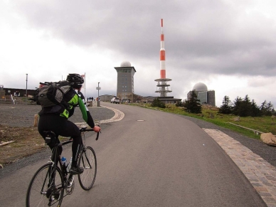
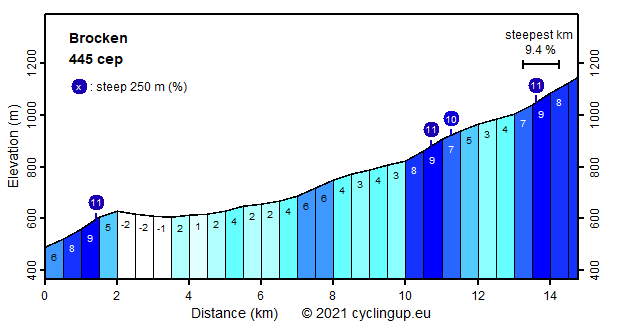
Every German knows what the Brocken is. The Brocken (1141 m) is the highest point of the Harz and hence the highest point of northern Germany. Largely due to the Brocken Railway, its summit is visited by a large number of tourists, which can be quite annoying for the cyclists. When I was there, I hardly saw anybody else nor did I enjoy the promised wide view from the summit. My reward was a cold rain and a view of 10 meters, conditions that occur frequently at this place. The first 2 kilometers of the climb, which are fairly steep (5-9%), are followed by a descend of 25 elevation meters. After passing the village of Schierke the excellently paved road is barred for motorised vehicles, so it is perfect for cyclists. The 10 kilometers from Schierke to the top can be divided into a relatively easy first half (2-6%) and a harder second half (up to 9% for the 500 meter intervals). Except for the area near the top, the surroundings of the road are heavily forested.
Rijd op 21 maart deze prachtige tocht vanuit Wageningen over de Veluwe. Keuze uit 80 en 125 km met resp. 580 en 990 hoogtemeters. Inschrijving vanaf 31 december
Tour for Life
Rijdt deze zomer de unieke en klassieke 8-daagse wielrentocht van Noord-Italië naar Zuid-Nederland voor Artsen zonder Grenzen!