
Pico de las Nieves-west
CyclingUp: Pico de las Nieves-west
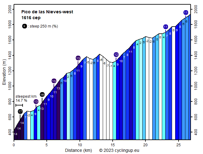
Climbing effort: 1619 cep
Elevation meters: 1821
Steepest kilometer: 14.7%
Steepest 250 m: 16%
Foot: 427 m Top: 1939 m
Mean slope: 5.6%
Length: 26.8 km
From: Embalse_del_Parralillo
Road conditions (2022): moderate
Other race bikers: 0-1 per hour
Motor vehicles: <10 per hour
Scenery and road:
Restaurant or bar near top: no
PHOTOS
SW NE LF S NW SIDE Download gpx

This is the hardest climb
(1616
climb effort points) on Gran Canaria on this website,
but perhaps also the most scenic.
From the very beginning, at the Embalse (reservoir) del Parralillo,
until you pass the parking area near the Roque del Nublo after 18 kilometres,
the mountain scenery is magnificent.
The rugged mountains are steep and sparsely vegetated;
they surround you on all sides, display beautiful colours,
and are embellished by two typical white Gran Canaria villages
(El Carrizal and Toscón de Arriba).
I hardly saw any motorised traffic here.
The downside, during the first 12 kilometres and also beyond Ayacata,
is the surface of the narrow road. It is often miserable.
The climb should actually begin in La Aldea de San Nicolás,
but unfortunately the road between La Aldea
and the reservoir was closed during my stay on Gran Canaria.
Therefore, the route on this website starts at the reservoir,
at the junction of
the climb described here and the
parallel climb to the Pico de las Nieves via Artenara.
The beginning of the ride is the hardest part.
Over the first 11 kilometres,
the average gradient is 8.7%,
but the variations in steepness are enormous.
There are short recovery sections,
but also no fewer than ten 500-metre segments of 10% or more.
Two 250-metre stretches reach 16 and 17%.
The nastiest section is the first kilometre and a half
(average 14.2%).
Here the cyclist is challenged not only by the steepness of the road,
but also by the terrible “asphalt”.
We actually walked part of the descent here!
After 11 kilometres of riding, an unnamed pass is reached.
A short descent follows,
then, finally on good asphalt, an ascent
and a somewhat longer descent.
In Ayacata we turn left
towards Pico de las Nieves (GC-600).
From here, roughly 12 kilometres remain to the highest point (1939 m).
During the first 3 kilometres, up to the parking area
near the Roque Nublo,
the poorly paved road is rather steep again (8–10%).
Beautiful mountains still surround the road.
After the parking area, everything changes.
The mountains are not steep and rugged anymore,
and a forest of tall conifers replaces the low vegetation.
Also, the road is generally far less steep.
Sometimes it even descends slightly,
there are also a few steep sections
(two 250-metre stretches of 11%).
After leaving the GC-600,
the road surface is in very good condition again.
From the summit, in clear weather,
you can view almost the entire island.
Rijd op 21 maart deze prachtige tocht vanuit Wageningen over de Veluwe. Keuze uit 80 en 125 km met resp. 580 en 990 hoogtemeters. Inschrijving vanaf 31 december
Tour for Life
Rijdt deze zomer de unieke en klassieke 8-daagse wielrentocht van Noord-Italië naar Zuid-Nederland voor Artsen zonder Grenzen!