
Pico de las Nieves-south
CyclingUp: Pico de las Nieves-south
Climbing effort: 1444 cep
Elevation meters: 2248
Steepest kilometer: 10.0%
Steepest 250 m: 12%
Foot: 55 m Top: 1939 m
Mean slope: 4.0%
Length: 46.6 km
From: Playa_del_Inglés
Road conditions (2022): average
Other race bikers: 10-25 per hour
Motor vehicles: 60-180 per hour
Scenery and road:
Restaurant or bar near top: no
PHOTOS
SW NE LF W NW SIDE Download gpx

On this website the climb from Playa del Inglés
is the longest (46.6 kilometers)
of all climbs to the Pico de las Nieves.
I didn't find the traffic disturbing
but there was a lot more traffic here
than during most other climbs
that I biked on Gran Canaria.
The description can be divided into three parts.
On the first 24 kilometers from Playa del Inglés (55 m) to
San Bartolome de Tirajana (890 m)
the well paved (in 2022) road (GC-60)
runs mostly through a valley heading straight northward.
The first 8 kilometers (3-9%) take place
in a desert-like landscape and
are a bit boring
but they are followed by a very beautiful descent (122 meters in altitude)
from the Degollada de las Yeguas (mare pass)
down to the aforementioned valley.
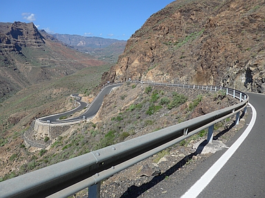
The valley is bordered by steep mountains
and the road winds
downhill along the rock face on the east side.
If you look closely
you can, already from the Degollada de las Yeguas,
see the destination of the ride
situated on the ridge at the end of the valley,
to the left of the masts on that same ridge.
After the descent, the road gradually gains height again.
The most difficult (6-8%) are the 4 kilometers after Fataga,
characterized by several hairpin bends.
After that still three kilometers remain to San Bartolomé.
These mostly run through a forest,
climb gently at first (1-3%)
and demand no more effort during the descent after the Alto de Fataga
(loss of 63 meters in altitude).
The terraces in San Bartolomé look inviting.
The road surface of the second part of the climb
(San Bartolomé-Ayacata;
a little more than 11 kilometers long) is miserable (in 2022).
Also, the sun usually is merciless here since there are
hardly any trees.
On the first six kilometers ending at the
Degollada de Cruz Grande,
the road runs steadily uphill (mostly 6-8%).
After that there is hardly any climbing (maximum 3%)
until Ayacata (1310 m).
In the last few kilometers before Ayacata,
the landscape with rugged, steep mountains becomes more impressive.
In Ayacata we turn right
heading for the Pico de las Nieves (GC-600).
The highest point of the road (1939 m) lies just below this peak
at a distance of 12 kilometers from Ayacata.
On the first 3 kilometers, ending at the parking lot near
the Roque Nubio, the gradient is considerable (8-10%)
while the surface of the road is miserable again.
Beautiful mountains still surround the road.
Everything changes after the parking lot.
The mountains become rolling instead of steep
and a forest of tall conifers replaces the low vegetation.
The road also generally gets much less steep,
drops a bit at times but also includes some steep sections
(two 250 meter strips at 11%).
After leaving the GC-600 the road surface is
in very good condition again.
In clear weather you can
overlook almost the whole island from the summit.
Rijd op 21 maart deze prachtige tocht vanuit Wageningen over de Veluwe. Keuze uit 80 en 125 km met resp. 580 en 990 hoogtemeters. Inschrijving vanaf 31 december
Tour for Life
Rijdt deze zomer de unieke en klassieke 8-daagse wielrentocht van Noord-Italië naar Zuid-Nederland voor Artsen zonder Grenzen!