
Pico de las Nieves-southwest
CyclingUp: Pico de las Nieves-southwest
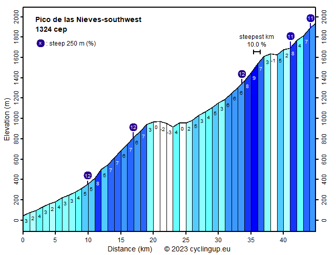
Climbing effort: 1324 cep
Elevation meters: 2121
Steepest kilometer: 10.0%
Steepest 250 m: 12%
Foot: 44 m Top: 1939 m
Mean slope: 4.2%
Length: 44.9 km
From: Puerto_de_Mogán
Road conditions (2022): average
Other race bikers: 5-10 per hour
Motor vehicles: 30-60 per hour
Scenery and road:
Restaurant or bar near top: no
PHOTOS
S NE LF W NW SIDE Download gpx
This climb from Puerto de Mogán to the Pico de las Nieves
is a real pleasure for cyclists.
The causes are mainly the way the road winds upwards
between km 10 (Mogán) and 20 (Cruz de San Antonio)
after the start,
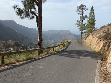
and the fantastic landscape between
Km 10 (Mogán) and 37 (parking lot near Roque Nubio).
In addition there is little traffic on the road,
especially between Mogán and Ayacata.
The description of the ride can be divided into three parts.
The first part (20 kilometers) runs from Puerto de Mogán
to the Cruz de San Antonio.
Over the first 10 kilometers after the start at Puerto de Mogán
cycling is quite easy (mostly 2-5%) on the relatively
busy GC-200.
This section is not very exciting
but that changes immediately after turning right onto the GC-605.
Right at the beginning there is a steep section of 250 meters (12%).
The next fork of the GC-605,
the side road towards Barranquillo Andrés,
is, as the crow flies, only 2.1 kilometers away
but the road needs almost 9 kilometers to get there.
With the help of many, many bends and hairpin bends
540 meters in altitude are overcome.
Just before the end of this section
there are excellent view points
for looking back on this part of the ascent.
The biker is also awarded by the impressive steep, barren mountains.
The road is narrow and generally not very steep
(except one, all 500 meter segments have a gradient between 5 and 9%).
A kilometer and a half after the side road towards Barranquillo Andrés
the Cruz de San Antonio (968 m) is reached.
Over the next 14 kilometers,
which connect the Cruz de San Antonio with Ayacata,
only 340 elevation meters are overcome.
It's not really steep anywhere
with a maximum of 6% in the last 3 kilometers before Ayacata.
However, this is one of the most scenic sections
that I cycled on Gran Canaria.
The landscape is most beautiful in the green forests,
when brown and orange-colored rocks line the road
and high steep mountains rise above it.
Road conditions are typical for Gran Canaria:
partly fantastic, partly miserable.
In Ayacata we turn left
heading for the Pico de las Nieves (GC-600).
The highest point of the road (1939 m) lies just below this peak
at a distance of 12 kilometers from Ayacata.
On the first 3 kilometers, ending at the parking lot near
the Roque Nubio, the gradient is considerable (8-10%)
while the surface of the road is miserable again.
Beautiful mountains still surround the road.
Everything changes after the parking lot.
The mountains become rolling instead of steep
and a forest of tall conifers replaces the low vegetation.
The road also generally gets much less steep,
drops a bit at times but also includes some steep sections
(two 250 meter strips at 11%).
After leaving the GC-600 the road surface is
in very good condition again.
In clear weather you can
overlook almost the whole island from the summit.
Rijd op 29 augustus deze prachtige klimtocht vanuit Wageningen over de Veluwe, door Montferland, Reichswald en Rijk van Nijmegen. Keuze uit 105 en 155 km met resp. 800 en 1180 hoogtemeters. Inschrijving vanaf nu
Tour for Life
Rijdt deze zomer de unieke en klassieke 8-daagse wielrentocht van Noord-Italië naar Zuid-Nederland voor Artsen zonder Grenzen!