
Col de la Loze-east
CyclingUp: Col de la Loze-east
Climbing effort: 1152 cep
Elevation meters: 1507
Steepest kilometer: 10.8%
Steepest 250 m: 15%
Foot: 848 m Top: 2307 m
Mean slope: 6.6%
Length: 22.1 km
From: la_Perriere
Road conditions (2022): good
Other race bikers: 1-5 per hour
Motor vehicles: <10 per hour
Scenery and road:
Restaurant or bar near top: yes
PHOTOS
W SIDE Download gpx

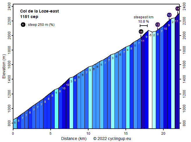
This climb from the Vallée de Bozel to the Col de la Loze runs through Courchevel. The first 17 kilometers are the same as the first 17 kilometers of the ascent to Courchevel Altiport. This part bridges 1122 meters in altitude so the average gradient is 6.6%. The surroundings of the road are not really pretty. The immediate vicinity is densely built up and the road is wide and full of traffic. This changes at the end of the buil-up area. A bit further, where the road turns left to the airport and enters a tunnel, we cycle straight ahead on a four meter wide cycle path leading to the pass while the road ends here for motorized traffic. The cycle path was opened in 2019. Up to the pass still 336 meters of altitude and a distance of 5 kilometers remain, which boils down to an average gradient of 6.6%, which is identical to the gradient of the first 17 kilometers of the ride. Hence, cycling is not that hard, you might think, but that is definitely not correct. The slope varies enormously. Sometimes the road drops (33 meters of altitude, in total) but there are also very steep passages (15% for the steepest 250 meters). The path looks like a playground for cyclists and the question arises whether the builders constructed the path to create something unique. The mountain massif (including Sommet de la Saulire, 2740 meters), on the flanks of which the cycle path was built, is impressive. At the pass itself a wide view opens up. I saw Mont Blanc and the Écrins, among others. The bike path continues on the other side of the mountain towards Meribel.
Rijd op 21 maart deze prachtige tocht vanuit Wageningen over de Veluwe. Keuze uit 80 en 125 km met resp. 580 en 990 hoogtemeters. Inschrijving vanaf 31 december
Tour for Life
Rijdt deze zomer de unieke en klassieke 8-daagse wielrentocht van Noord-Italië naar Zuid-Nederland voor Artsen zonder Grenzen!