HOME cyclingup.eu

regions

method
contact
links
French Alps
Switzerland
Austria
Italian Alps
French Pyrenees
Spain
Gran Canaria
Vosges
Black Forest
Brocken, Germany
Ardennes
Netherlands
Courchevel-altiport
CyclingUp: Courchevel-altiport
Climbing effort: 845 cep
Elevation meters: 1171
Steepest kilometer: 9.7%
Steepest 250 m: 12%
Foot: 848 m Top: 2008 m
Mean slope: 6.7%
Length: 17.4 km
From: la_Perriere
Road conditions (2012): average
Other race bikers: 1-5 per hour
Motor vehicles: 60-180 per hour
Scenery and road:
Restaurant or bar near top: yes
PHOTOS Download gpx
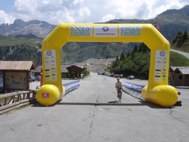
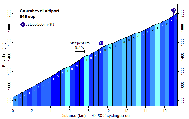
This climb begins at the roundabout where the road to Courchevel (D91) bifurcates from the N515. It passes through some villages, amoung which Le Praz with its ski jump. Our track circumvents Courchevel 1550 and passes through Courchevel 1650 and Courchevel 1850 to end at a tiny airport (altiport). The slope is variable, one of the most tiring parts being the last kilometer, where the slope of the road (8-9% but 12% for a section of 250 meters) cannot be estimated in the barren landscape. Much of the direct surroundings of the road is ugly due to the ski resorts and the lack of vegetation in the upper parts. Traffic is dense, especially in the lower parts of the climb.
Camping Les Erables .
Tip!
Ideal starting point for Col du Grand Colombier and Col de la Biche.
Warm hospitality and swimming pool nearby.
Germania klimtocht
Rijd op 29 augustus deze prachtige klimtocht vanuit Wageningen over de Veluwe, door Montferland, Reichswald en Rijk van Nijmegen. Keuze uit 105 en 155 km met resp. 800 en 1180 hoogtemeters. Inschrijving vanaf nu
Tour for Life
Rijdt deze zomer de unieke en klassieke 8-daagse wielrentocht van Noord-Italië naar Zuid-Nederland voor Artsen zonder Grenzen!