
Col de la Loze-west
CyclingUp: Col de la Loze-west
Climbing effort: 1448 cep
Elevation meters: 1679
Steepest kilometer: 12.2%
Steepest 250 m: 16%
Foot: 633 m Top: 2307 m
Mean slope: 7.8%
Length: 21.4 km
From: Brides-les-Bains
Road conditions (2022): good
Other race bikers: 10-25 per hour
Motor vehicles: <10 per hour
Scenery and road:
Restaurant or bar near top: yes
PHOTOS
E SIDE Download gpx

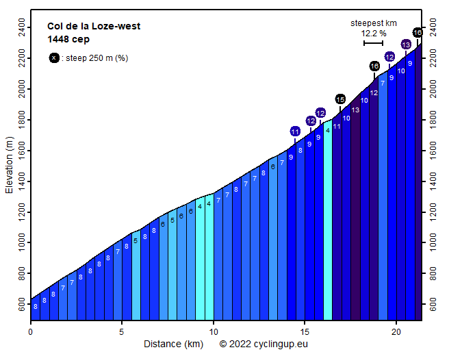
The climb from Brides-les-Bains to the Col de la Loze is quite long (just over 21 kilometers) and overcomes a large number of meters in altitude (1674). The first 14.5 kilometers are not that exciting. The average gradient is 7.0% and only just before the end of this section the slope exceeds 8%. The wide and busy road leads to and through Meribel, a gigantic winter sports resort. But then, at the end of the built-up area of Meribel, everything changes. Here you find a billboard with information about the continuation of the ascent to the Col de la Loze. It marks the beginning of a cycle path, about four meters wide, leading to the pass while the road ends here for motorized traffic. The cycle path was opened in 2019 and a year later it formed the last part of a stage of the Tour de France. On the internet I had seen a profile and thus I knew that the last 7 kilometers would be hard with an average slope of 9.5%. However, it turned out that the slope of the path varies tremendously. Partly the bike path runs almost horizontally, then it tilts 20% or more. This outstanding variability is present from the beginning to the end and occurs at all kinds of length scales, and is therefore only partially visible in the profile. The path looks like a playground for cyclists and the question arises whether the builders constructed the path to create something unique. Anyway, it's a tough job getting up here, that means for me and other race bikers. Were the many e-bikers also that exhausted? At the pass itself a wide view opens up. I saw Mont Blanc and the Écrins, among others. The bike path continues on the other side of the mountain towards Courchevel.
Rijd op 21 maart deze prachtige tocht vanuit Wageningen over de Veluwe. Keuze uit 80 en 125 km met resp. 580 en 990 hoogtemeters. Inschrijving vanaf 31 december
Tour for Life
Rijdt deze zomer de unieke en klassieke 8-daagse wielrentocht van Noord-Italië naar Zuid-Nederland voor Artsen zonder Grenzen!