Alto de la Pandera-north

CyclingUp: Alto de la Pandera-north

Climbing effort: 1015 cep
Elevation meters: 1328
Steepest kilometer: 13.4%
Steepest 250 m: 14%
Foot: 581 m Top: 1828 m
Mean slope: 5.3%
Length: 23.5 km
From: Los Villares
Road conditions (2022): moderate
Other race bikers: 10-25 per hour
Motor vehicles: <10 per hour
Scenery and road:
Restaurant or bar near top: no
PHOTOS
S SIDE Download gpx

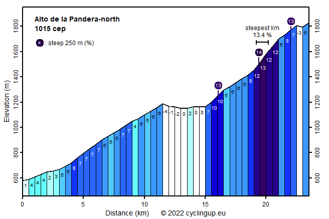
The climb to the Alto de la Pandera from Los Villares is probably the hardest in the province of Jaén. This is mainly due to the large number of meters in altitude (1328) and to the very steep section that begins about 4.5 kilometers from the finish. In that section 246 meters in altitude are overcome over a distance of two kilometers, corresponding to an average gradient of 12.3%. The ride consists of an approach on the C-3221 and the A-6050, and then the real climbing on a narrow road, more or less over the mountain ridge up to a point just below the summit of the Pandera. The 15 kilometer long approach from Los Villares bridges almost 600 meters in altitude (582), so you don't necessarily start the actual climbing with fresh legs. Thanks to the vegetation with lots of gorse, I found the first part of the approach, ending in the big right-hand bend at the Urbanización la Pandera, the most beautiful. The last 2.5 kilometers before the Urbanización are the steepest of the approach (7-8%). After the turnoff to Fuensanta de Martos (JA-3301) little height is gained for some time. That then changes abruptly 3.5 kilometers further on at the turnoff (without sign) to the Pandera. The remaining 8.5 kilometers to the finish include three very steep parts. Shortly after the turnoff there is a strip with a length of one kilometer that has a slope of 10%. After that, cycling is a little easier (2.5 kilometers of 5-8%). Then follow the already mentioned very steep passage of 2 kilometers long, another relatively easy section (6-8%) and again a killing passage (250 meters of 13%). Finally, the road dives steeply downhill and then climbs up again. The asphalt ends at a closed gate about 30 meters below the summit. While riding the last few kilometers, the cyclist is rewarded with views in all directions. During clear atmospheric conditions the Sierra Nevada is visible .


For tours in the splendid and varied nature of Asturias.
Grazalema Cycling Adventures offers guided bike tours and rents road, mountain and electric bikes in splendid Andalusia.
Camping Alpujarras in Laroles, along the road to the Puerto de la Ragua, offers superb views, green grass, good meals and great hospitality.
Rijd op 22 maart deze prachtige tocht over de Veluwe, 75 of 125 kilometer vanuit Wageningen. Met veel hoogtemeters: resp. 550 en 970. Inschrijving
1K Ride
Rijd op 15 juni deze tocht met meer dan 1000 hoogtemeters; 80, 120 of 145 kilometer vanuit Oosterbeek. Inschrijving
Tour for Life
Rijdt deze zomer de unieke en klassieke 8-daagse wielrentocht van Noord-Italië naar Zuid-Nederland voor Artsen zonder Grenzen!

