Mont Ventoux-east

CyclingUp: Mont Ventoux-east

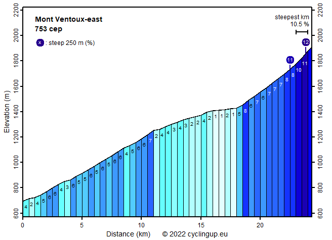
Climbing effort: 753 cep
Elevation meters: 1216
Steepest kilometer: 10.5%
Steepest 250 m: 12%
Foot: 695 m Top: 1911 m
Mean slope: 5.0%
Length: 24.3 km
From: Sault
Road conditions (2020): good
Other race bikers: >25 per hour
Motor vehicles: 30-60 per hour
Scenery and road:
Restaurant or bar near top: yes
PHOTOS
S W SIDE Download gpx

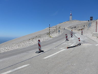
The climb from Sault to the top of Mont Ventoux is the easiest of the three climbs on this famous mountain. This ride has only 1216 elevation meters, compared to 1602 and 1581 meters for the ascents from Bédoin and Malaucène, respectively. The mean slope of 5.0% is also much less than for the other two climbs (both 7.5%). However, the ascent takes place in a lovely landscape, partly due to the first two kilometers in which the road winds up between lavender fields in an open landscape. After that the road enters into the forest so views become scarce. However, the forest is beautiful and the street is neither wide nor busy. The first eleven kilometers are not steep (mostly 5-6%). The next seven kilometers, ending at Chalet Reynard, are even easier (1-4%). Finally there are six kilometers left, which this ascent shares with the ascent from Bédoin, through the famous lunar landscape to the summit. Here the road is steeper, initially around 7% but then getting steeper and steeper and finally a kilometer with a gradient of 10.5%, the steepest of the ride. I was suffering a bit here due to a head wind and the relatively thin air.


Rijd op 22 maart deze prachtige tocht over de Veluwe, 75 of 125 kilometer vanuit Wageningen. Met veel hoogtemeters: resp. 550 en 970. Inschrijving
1K Ride
Rijd op 15 juni deze tocht met meer dan 1000 hoogtemeters; 80, 120 of 145 kilometer vanuit Oosterbeek. Inschrijving
Tour for Life
Rijdt deze zomer de unieke en klassieke 8-daagse wielrentocht van Noord-Italië naar Zuid-Nederland voor Artsen zonder Grenzen!

