
Mont Ventoux-west
CyclingUp: Mont Ventoux-west
Climbing effort: 1358 cep
Elevation meters: 1581
Steepest kilometer: 11.6%
Steepest 250 m: 13%
Foot: 330 m Top: 1911 m
Mean slope: 7.5%
Length: 21.0 km
From: Malaucène
Road conditions (2020): excellent
Other race bikers: >25 per hour
Motor vehicles: 60-180 per hour
Scenery and road:
Restaurant or bar near top: yes
PHOTOS
S E SIDE Download gpx
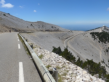

This climb to the top of Mont Ventoux begins in Malaucène and is a little harder than the famous ascent from Bédoin (1358 versus 1333 climb effort points). Though the climb from Malaucène is 21 meters less in elevation meters than the climb from Bédoin, during the first the elevation meters are gained on a steeper slope, on average. However, the ride from Malaucène lacks the charm of the ride from Bédoin with its narrow steep road through a dense forest and its long section through the lunar landscape around the summit of the mountain. If you start in Malaucène, the first 15 kilometers are pretty boring. The road is wide, hairpin bends are scarce and the views are not very exciting. The road constantly remains near the ridge of the Mont Ventoux. The steepest part (average slope 10.0%) begins after almost ten kilometers and has a length of four kilometers. This steep part ends with the steepest kilometer of the entire climb (11.6%). After 15 kilometers of cycling, past a winter sports resort (Station du Mont Serein), the road becomes narrower and hence the ride gets more exciting. Still six kilometers remain to the summit, the last one and a half of which are the most impressive. Here the road winds across the bare rocky slopes under the top of the mountain, which is crowned by a building that resembles a lighthouse while in reality it is a radio tower.
Rijd op 21 maart deze prachtige tocht vanuit Wageningen over de Veluwe. Keuze uit 80 en 125 km met resp. 580 en 990 hoogtemeters. Inschrijving vanaf 31 december
Tour for Life
Rijdt deze zomer de unieke en klassieke 8-daagse wielrentocht van Noord-Italië naar Zuid-Nederland voor Artsen zonder Grenzen!