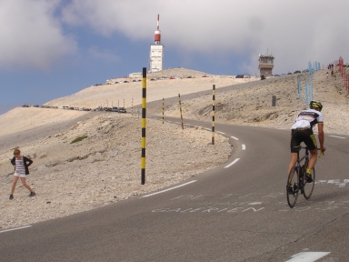
Mont Ventoux-south

CyclingUp: Mont Ventoux-south

Climbing effort: 1333 cep
Elevation meters: 1602
Steepest kilometer: 11.0%
Steepest 250 m: 12%
Foot: 309 m Top: 1911 m
Mean slope: 7.5%
Length: 21.5 km
From: Bédoin
Road conditions (2013): good
Other race bikers: >25 per hour
Motor vehicles: >180 per hour
Scenery and road:
Restaurant or bar near top: no
PHOTOS
W E SIDE Download gpx

The climb from Bédoin to the summit of Mont Ventoux is a classic for race cyclists. From 1951 to 2013 Mont Ventoux has been the final 22 kilometers in 15 Tour de France stages. Here during the Tour of 1967 British Tom Simpson collapsed under the influence of heat and amfetamine and died when he was transported to the hospital. The Mont Ventoux also is a landmark, situated so far west and near the Rhone valley. The Ventoux forms a mix of the Alps and the Mediterranean. After the first 6 kilometers up to Saint-Estève (mean slope of 4.4%), the hardest part of the tour begins and will not end until just before Le Chalet Reynard. The road winds itself with a slope of mostly 9-10% through the forest. The famous barren moon-like and often wind-swept landscape lies between Le Chalet Reynard and the top. Here the slope is somewhat reduced (mostly 6-7%) but towards the end there is a steepening up to 11% for a 500-meter-interval and even 12% for a section of 250 meters.


Rijd op 30 augustus deze prachtige klimtocht vanuit Wageningen over de Veluwe, door Montferland, Reichswald en Rijk van Nijmegen. Keuze uit 105 en 155 km met resp. 750 en 1130 hoogtemeters. Inschrijven vanaf 22 juni
Tour for Life
Rijdt deze zomer de unieke en klassieke 8-daagse wielrentocht van Noord-Italië naar Zuid-Nederland voor Artsen zonder Grenzen!

