
Col de la Croix de Fer-east
CyclingUp: Col de la Croix de Fer-east
Climbing effort: 1295 cep
Elevation meters: 1671
Steepest kilometer: 10.4%
Steepest 250 m: 12%
Foot: 549 m Top: 2067 m
Mean slope: 5.2%
Length: 29.1 km
From: St-Jean-de-Maurienne
Road conditions (2025): good
Other race bikers: 10-25 per hour
Motor vehicles: 60-180 per hour
Scenery and road:
Restaurant or bar near top: yes
PHOTOS
N W SIDE Download gpx

Between 1947 and 2024, the Col de la Croix de Fer
was included in the route of the Tour de France
no fewer than 21 times.
This makes it a famous pass
that every climbing enthusiast likes to tick off.
Starting in Saint-Jean-de-Maurienne,
it is a long ride to the pass (29 kilometres),
and a large number of elevation metres have to be overcome (1671).
The Croix de Fer is not only well known,
but it is also an Hors Catégorie climb.
The route is varied,
both from a sporting and a scenic point of view.
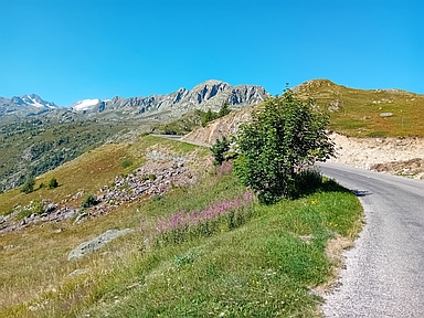
The most beautiful part is the final 4.5 kilometres,
which begin where the built-up area
of Saint-Sorlin-d’Arves ends.
Here the road rises above the tree line
and offers views of high mountains all around,
including snow- and ice-covered parts of the Écrins
and the three sharp, pointed peaks
of the Aiguilles d’Arves (3510 m).
What disappointed me
was the relatively heavy traffic
over the entire length of the climb.
The ride begins with about 4 kilometres of climbing (6–9%)
up to the junction of the road to La Toussuire.
This is followed by a section
that runs mostly downhill
(a net loss of 63 elevation metres).
After that, the road climbs
along the orographically left side
of the gorge-like valley of the Arvan,
a section of more than 5 kilometres
with 470 metres of elevation gain (8–9%).
Next comes an almost horizontal section
with three well-lit tunnels,
followed by another descent, where again
63 elevation metres are lost.
After the junction towards Albiez-le-Vieux,
the road continues with a relatively gently ascending section (3–6%)
until, after about 7 kilometres,
Saint-Sorlin-d’Arves is reached.
In this tourist village the road quickly becomes steeper,
including the steepest kilometre of the entire route (10.4%),
which forms a tough lead-out
for the beautiful final kilometres described above (8%).
Rijd op 21 maart deze prachtige tocht vanuit Wageningen over de Veluwe. Keuze uit 80 en 125 km met resp. 580 en 990 hoogtemeters. Inschrijving vanaf 31 december
Tour for Life
Rijdt deze zomer de unieke en klassieke 8-daagse wielrentocht van Noord-Italië naar Zuid-Nederland voor Artsen zonder Grenzen!