
Glandon-Croix de Fer-north
CyclingUp: Glandon-Croix de Fer-north
Climbing effort: 1289 cep
Elevation meters: 1636
Steepest kilometer: 10.8%
Steepest 250 m: 12%
Foot: 450 m Top: 2067 m
Mean slope: 6.7%
Length: 24.0 km
From: St-Etienne-de-Cuines
Road conditions (2018): average
Other race bikers: 10-25 per hour
Motor vehicles: 10-30 per hour
Scenery and road:
Restaurant or bar near top: yes
PHOTOS
E W SIDE Download gpx
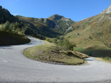

This climb begins at the turnoff of the D927 from the D1006, a little north of Saint-Étienne-de-Cuines. From here a 21-kilometer long road leads to the Col du Glandon through the almost straight valley of the creak Glandon. The first two kilometers through Saint-Étienne are easy (maximum 4%) but then a long (8 kilometers), winding and rather monotonous section with an inclination of mostly 7% follows , the end of which is in St-Colomban-des-Villards. From there, the ride becomes more exciting beginning with another three and a half kilometers that are not that hard yet (0-8%). Beyond La Chal the tarmac gets really steep. While the road narrows and crosses a beautiful forest, the slope varies between 8 and 11%. After leaving the forest, there are many views. Here one can fully enjoy the cycling, on a quiet road, at least on the sunny Monday in September when I biked up here. A short, less steep section (5%) offers the opportunity to recover somewhat before the final two and a half kilometers to the Glandon (9-11%) exhaust the cyclist, partly because a lot of work has been done before. After this first pass, 14 elevation meters are lost in a descent. At the fork, keep left and continue, for another three kilometers to the Col de la Croix de Fer. All in all, this ascent is, in terms of climbing effort (1289 climb effort points or cep), elevation meters (1636) and steepest kilometer (11.1%), almost equivalent to the famous ascent to the Mont Ventoux from Bédoin (1333 cep, 1602 meters and 11.0%).
Rijd op 21 maart deze prachtige tocht vanuit Wageningen over de Veluwe. Keuze uit 80 en 125 km met resp. 580 en 990 hoogtemeters. Inschrijving vanaf 31 december
Tour for Life
Rijdt deze zomer de unieke en klassieke 8-daagse wielrentocht van Noord-Italië naar Zuid-Nederland voor Artsen zonder Grenzen!