
Gotthardpass-north
CyclingUp: Gotthardpass-north
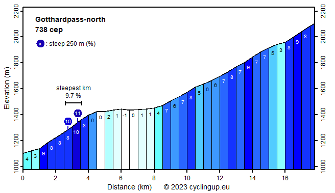
Climbing effort: 738 cep
Elevation meters: 1019
Steepest kilometer: 9.7%
Steepest 250 m: 11%
Foot: 1102 m Top: 2106 m
Mean slope: 5.6%
Length: 17.8 km
From: Göschenen
Road conditions (2020): moderate
Other race bikers: 0-1 per hour
Motor vehicles: 60-180 per hour
Scenery and road:
Restaurant or bar near top: yes
PHOTOS Download gpx

The climb to the Gotthard Pass from the north
starts in Göschenen.
After a one kilometer long, easy approach (3-4%)
the route turns sharply to the right onto the main road.
Over the next three kilometers the ride continues
through a steep valley, which toward the end even becomes a gorge,
the so-called Schöllenen.
This was for a long time
an insurmountable obstacle for the construction
of a continuous road across the Gotthard,
until in 1198 the Teufelsbrücke (Devil's Bridge) was completed.
There is a lot of traffic in the Schöllenen (and there is a railway).
Fortunately, one may leave the road
after the fourth hairpin bend (which turns left)
and continue on a cycle path that is mostly
well separated from the road.
This path is often utterly steep, though never over a long distance.
Here lies the steepest kilometer of the entire trip (9.7%).
After the Schöllenen, the road runs
almost horizontal for about four kilometers.
In this section you cycle through Andermatt,
where the road to the
Oberalppass branches off to the left.
After Andermatt, the ride continues to Hospental,
where the slope becomes considerable again.
More than nine kilometers remain to the pass,
which, however, are nowhere steeper than 9%.
The mountains on either side of the road are made up of
a mosaic of gray gneiss and grass.
Trees and steep rock faces are missing,
so the landscape is pretty colorless.
First one cycles on the wide, well-paved main road
but for the last three kilometers I chose the "old road".
It turned out that the longest part of it
is covered by cobblestones.
That's probably authentic
but doesn't exactly make cycling pleasant.
The pass lies about half a kilometer
before the clearly visible Ospizio.
The ascent suggested here can be extended
by beginning in Amsteg, from Göschenen further down in the Reussdal.
This would increase the distance by 16.2 kilometers,
the number of meters in altitude with 623
and the climbing effort by 357
climb effort points.
Rijd op 21 maart deze prachtige tocht vanuit Wageningen over de Veluwe. Keuze uit 80 en 125 km met resp. 580 en 990 hoogtemeters. Inschrijving vanaf 31 december
Tour for Life
Rijdt deze zomer de unieke en klassieke 8-daagse wielrentocht van Noord-Italië naar Zuid-Nederland voor Artsen zonder Grenzen!