Colle dell'Agnello-south

CyclingUp: Colle dell'Agnello-south

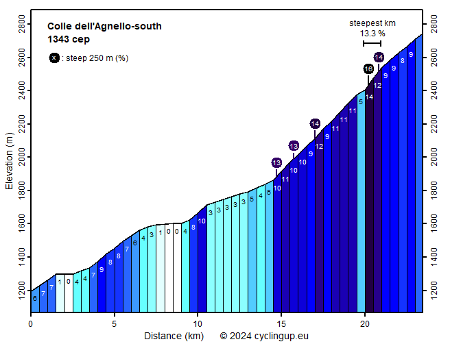
Climbing effort: 1343 cep
Elevation meters: 1563
Steepest kilometer: 13.3%
Steepest 250 m: 16%
Foot: 1195 m Top: 2744 m
Mean slope: 6.6%
Length: 23.5 km
From: Torrette
Road conditions (2020): average
Other race bikers: 10-25 per hour
Motor vehicles: 60-180 per hour
Scenery and road:
Restaurant or bar near top: no
PHOTOS
W SIDE Download gpx

The ascent to the Colle dell'Agnello (Col Agnel in French) from Italy consists of two parts. The first part (14.5 kilometers long) begins on the wide and busy road from Sampéyre to the pass (SP105), more precisely between the villages of Torrette and Caldane. Here the road begins to significantly gain altitude with four hairpin bends ("tornanti"). After the hairpin bends, steeper and easier sections alternate. For example, the two kilometers starting after 4 kilometers of cycling at Casteldelfino are steeper (7-9%). A little further the road follows the shores of a reservoir during one and a half kilometers and is therefore almost horizontal. Next, there is another steeper kilometer (8-10%), followed by four easy kilometers (mostly 3%). The second part of the climb begins one kilometer after the village of Chianale. This part is very different from the first part. There are 882 meters of altitude to be gained over a distance of 8.95 kilometers. The slope therefore averages 9.9%. The first 5 kilometers are the toughest with an average of 10.3%. After that you may recover in an only slightly ascending section of a few hundred meters long. This is immediately followed by the steepest kilometer of the ride (13.3%). On the last 2.5 kilometers the slope is not alarming (8-9%) but tiredness due to the kilometers already covered and the thin air will probably not make these parts easy for most cyclists.


Rijd op 21 maart deze prachtige tocht vanuit Wageningen over de Veluwe. Keuze uit 80 en 125 km met resp. 580 en 990 hoogtemeters. Inschrijving vanaf 31 december
Tour for Life
Rijdt deze zomer de unieke en klassieke 8-daagse wielrentocht van Noord-Italië naar Zuid-Nederland voor Artsen zonder Grenzen!

