
Col Agnel-west
CyclingUp: Col Agnel-west
Climbing effort: 1035 cep
Elevation meters: 1381
Steepest kilometer: 9.4%
Steepest 250 m: 13%
Foot: 1379 m Top: 2744 m
Mean slope: 6.6%
Length: 20.8 km
From: Ville Vieille
Road conditions (2013): average
Other race bikers: 10-25 per hour
Motor vehicles: 30-60 per hour
Scenery and road:
Restaurant or bar near top: no
PHOTOS VIDEO
S SIDE Download gpx

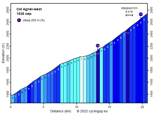
Never believe a col is easy before you have made it. This certainly holds for the French side of Col Agnel, with 2744 m the third highest pass in the Alps after the Col de l'Iseran and the Stelvio. The first 7.5 kilometers are moderately steep (mostly 6-8%). Towards the end of this section, at Molines-en-Queyreas, take the road to the left to enter the valley leading towards the pass. At 1.5 kilometers after the junction, a relatively easy section with reduced and variable steepness begins. Here some nice old-looking villages skirt the tranquil road. However, the final 7 kilometers are hard with slopes of mostly 8-9%. In addition, here I had a strong adverse wind on both occasions that I climbed the pass. From the col, nearby Monte Viso (3841 m) can be seen if the weather allows. This tour can be extended with a warming up from the bifurcation of the D902A and the N94 near Guillestre (difficulty 229 cep, climbing 584 m, length 25 km).
Rijd op 30 augustus deze prachtige klimtocht vanuit Wageningen over de Veluwe, door Montferland, Reichswald en Rijk van Nijmegen. Keuze uit 105 en 155 km met resp. 750 en 1130 hoogtemeters. Inschrijven vanaf 22 juni
Tour for Life
Rijdt deze zomer de unieke en klassieke 8-daagse wielrentocht van Noord-Italië naar Zuid-Nederland voor Artsen zonder Grenzen!