
Col Petit-Bernard-northeast
CyclingUp: Col Petit-Bernard-northeast
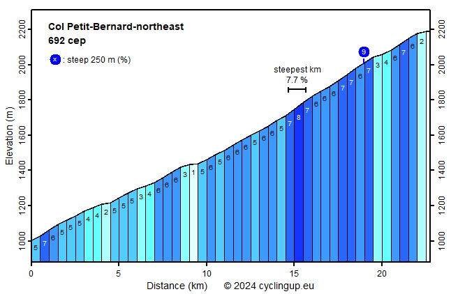
Climbing effort: 685 cep
Elevation meters: 1180
Steepest kilometer: 7.7%
Steepest 250 m: 9%
Foot: 1010 m Top: 2188 m
Mean slope: 5.2%
Length: 22.7 km
From: Pré-St._Didier
Road conditions (2018): good
Other race bikers: 10-25 per hour
Motor vehicles: 60-180 per hour
Scenery and road:
Restaurant or bar near top: yes
PHOTOS
SW SIDE Download gpx

This climb begins along the SS26 at the turnoff of the SS26D,
at an altitude of 1006 m in Pré-St.Didier.
This village is located in the Aosta Valley,
where some 68,000 people still speak a Franco-Provençal dialect,
Rijd op 21 maart deze prachtige tocht vanuit Wageningen over de Veluwe. Keuze uit 80 en 125 km met resp. 580 en 990 hoogtemeters. Inschrijving vanaf 31 december
Tour for Life
Rijdt deze zomer de unieke en klassieke 8-daagse wielrentocht van Noord-Italië naar Zuid-Nederland voor Artsen zonder Grenzen!