


Vallon d'Ambin

CyclingUp: Vallon d'Ambin

Climbing effort: 545 cep
Elevation meters: 656
Steepest kilometer: 11.9%
Steepest 250 m: 14%
Foot: 1227 m Top: 1855 m
Mean slope: 6.3%
Length: 10.0 km
From: Bramans
Road conditions (2025): moderate
Other race bikers: 0-1 per hour
Motor vehicles: 10-30 per hour
Scenery and road:
 (3/5)
(3/5) Restaurant or bar near top: no
PHOTOS Download gpx

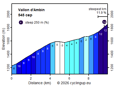
This short climb starts in Bramans, located in the wide valley of the Arc, and heads into a side valley on the orographic left side of the main valley. To reach this higher-lying side valley, the road is quite steep in the first part of the climb (a 3.5-kilometre section has an average gradient of 8.8%). After that, the road continues relatively easily through the Vallon d’Ambin to Le Planay (the gradient varies between –3 and 6%). If you keep left there, the road continues further into the Vallon d’Ambin. However, you cannot get very far by road bike. After about 2.5 kilometres, the asphalt ends, some 200 metres before the Plan de la Vie. The final kilometre is tough and the steepest of the entire climb (11.9%). At Le Planay, instead of turning left, you could also have turned right, into the Vallon d’Étache. Of the two options, I found that short climb to be more scenic than the continuation in the Vallon d'Ambin proposed here.
Rijd op 29 augustus deze prachtige klimtocht vanuit Wageningen over de Veluwe, door Montferland, Reichswald en Rijk van Nijmegen. Keuze uit 105 en 155 km met resp. 800 en 1180 hoogtemeters. Inschrijving vanaf nu
Tour for Life
Rijdt deze zomer de unieke en klassieke 8-daagse wielrentocht van Noord-Italië naar Zuid-Nederland voor Artsen zonder Grenzen!