
Col de l'Arpettaz-southwest
CyclingUp: Col de l'Arpettaz-southwest
Climbing effort: 928 cep
Elevation meters: 1185
Steepest kilometer: 10.1%
Steepest 250 m: 12%
Foot: 415 m Top: 1600 m
Mean slope: 7.2%
Length: 16.4 km
From: Ugine
Road conditions (2019): bad
Other race bikers: 1-5 per hour
Motor vehicles: <10 per hour
Scenery and road:
Restaurant or bar near top: yes
PHOTOS Download gpx
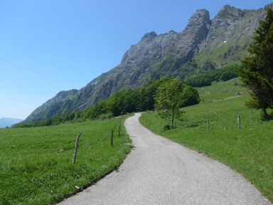
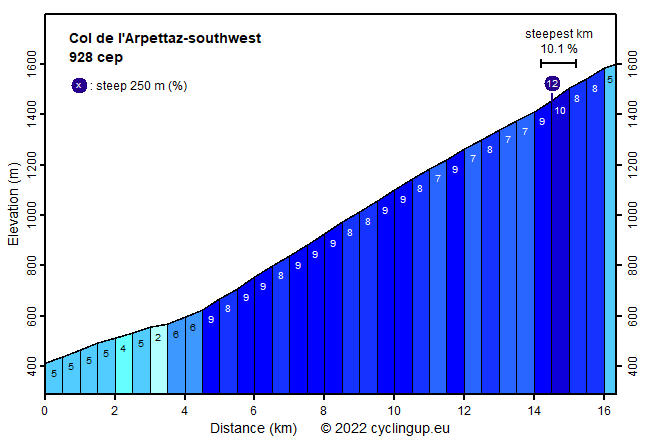
This climb has a special character. The majority of the ride takes place on a narrow road where oncoming cars can hardly pass each other. The road surface is nice in the beginning but as one progresses it gets worse, with holes and on the road all kinds of stuff that fell of the trees and, worse, gravel. Descending is not advisable but luckily an alternative that is in much better condition is available for the descent. This alternative heads towards to D109 and reaches it near Héry. However, apart from the road surface, this is a great climb. I only saw a few cars here, the road is exciting with many windings and the last few kilometers are superbly beautiful thanks to a wide view in a southerly direction and thanks to the nearby and rugged mountain walls of the Aiguilles de Mont, to the left of the climbing cyclist. The first two kilometers (5%) are used to leave Ugine. This is followed by somewhat more than two, easy kilometers (2-6%) but then, at a junction of the road, where one must keep to the right, the real work begins. Until the bar just before the pass, over a distance of 11.5 kilometer, the average slope measures 8.3% and easy sections for recovery are missing. While some short sections of a few dozen meters are very steep, the slope of the steepest kilometer is not too bad (10.1%). The road runs through the forest for a long time but the trees give way in the last few kilometers. As already mentioned views are impressive here and can be enjoyed on the terrace just before the pass.
Rijd op 29 augustus deze prachtige klimtocht vanuit Wageningen over de Veluwe, door Montferland, Reichswald en Rijk van Nijmegen. Keuze uit 105 en 155 km met resp. 800 en 1180 hoogtemeters. Inschrijving vanaf nu
Tour for Life
Rijdt deze zomer de unieke en klassieke 8-daagse wielrentocht van Noord-Italië naar Zuid-Nederland voor Artsen zonder Grenzen!