Col de Pontis-north

CyclingUp: Col de Pontis-north

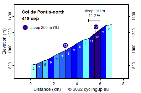
Climbing effort: 419 cep
Elevation meters: 496
Steepest kilometer: 11.2%
Steepest 250 m: 12%
Foot: 805 m Top: 1301 m
Mean slope: 7.1%
Length: 7.0 km
From: les Eygoires
Road conditions (2020): average
Other race bikers: 1-5 per hour
Motor vehicles: <10 per hour
Scenery and road:
Restaurant or bar near top: no
PHOTOS
S SIDE Download gpx

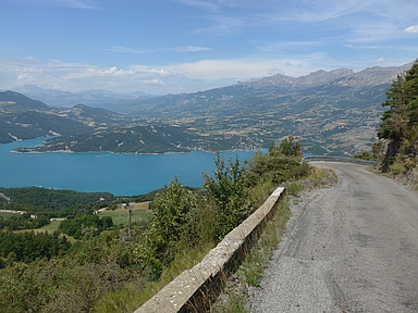
From the north the climb to the Col de Pontis (419 climb effort points or cep) is easier than from the south (492 cep). Because the number of meters in altitude is almost the same, the difference is caused by the slope. While in the ascent from the south the slope mostly fluctuates around 10%, in the ascent from the north 9% are only exceeded in a section just past the hamlet of Pontis. However, this section includes a kilometer with a gradient of 11.2%. The ride begins on the road (D954), which runs from Savines-le-Lac along the south coast of the reservoir, in the locality of Les Eygoires. From there we first cycle 2.5 kilometers on the D954 (2-9%) and then turn sharply to the left. During the next 2.5 kilometers a narrow road, surrounded by meadows and some forest (including a beech forest), leads to Pontis. After Pontis the already mentioned steepest part of the ride with a breathtaking panorama over the reservoir and the mountains beyond follows. The final half kilometer of the climb is almost horizontal and ends at the pass, which is only indicated with a tiny sign.


Rijd op 22 maart deze prachtige tocht over de Veluwe, 75 of 125 kilometer vanuit Wageningen. Met veel hoogtemeters: resp. 550 en 970. Inschrijving
1K Ride
Rijd op 15 juni deze tocht met meer dan 1000 hoogtemeters; 80, 120 of 145 kilometer vanuit Oosterbeek. Inschrijving
Tour for Life
Rijdt deze zomer de unieke en klassieke 8-daagse wielrentocht van Noord-Italië naar Zuid-Nederland voor Artsen zonder Grenzen!

