HOME cyclingup.eu

regions

method
contact
links
French Alps
Switzerland
Austria
Italian Alps
French Pyrenees
Spain
Gran Canaria
Vosges
Black Forest
Brocken, Germany
Ardennes
Netherlands
Col de Pontis-south
CyclingUp: Col de Pontis-south
Climbing effort: 492 cep
Elevation meters: 497
Steepest kilometer: 11.1%
Steepest 250 m: 12%
Foot: 804 m Top: 1301 m
Mean slope: 9.6%
Length: 5.2 km
From: Cimetière_d'Ubaye
Road conditions (2020): bad
Other race bikers: 5-10 per hour
Motor vehicles: <10 per hour
Scenery and road:
Restaurant or bar near top: no
PHOTOS
N SIDE Download gpx
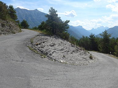
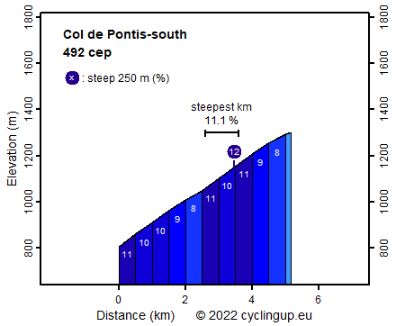
The climb to the Col de Pontis from Cimetière (cemetery) de Ubaye is not long (5.2 km) but with an effective slope of almost 10% (9.9% to be exact) it is pretty steep. Eight of the ten 500 meter segments have a gradient of 9, 10 or 11%. Also, some of the many hairpin bends are considerably steeper. Only a section with a length of about 200 meters, reached after more than two kilometers of cycling, and some sections in the last kilometer are relatively easy. The ride offers views on rugged mountains, especially in the east. In the valley lies the great Lac de Serre-Ponçon with its beautiful turquoise water surface. The asphalt is horrible (2020).
Camping Les Erables .
Tip!
Ideal starting point for Col du Grand Colombier and Col de la Biche.
Warm hospitality and swimming pool nearby.
Veluviatocht
Rijd op 21 maart deze prachtige tocht vanuit Wageningen over de Veluwe. Keuze uit 80 en 125 km met resp. 580 en 990 hoogtemeters. Inschrijving vanaf 31 december
Tour for Life
Rijdt deze zomer de unieke en klassieke 8-daagse wielrentocht van Noord-Italië naar Zuid-Nederland voor Artsen zonder Grenzen!