
-west
CyclingUp: -west
Climbing effort: cep
Elevation meters:
Steepest kilometer: %
Steepest 250 m: %
Foot: m Top: m
Mean slope: %
Length: km
From:
Road conditions ():
Other race bikers: per hour
Motor vehicles: per hour
Scenery and road:
Restaurant or bar near top:
PHOTOS VIDEO Download gpx
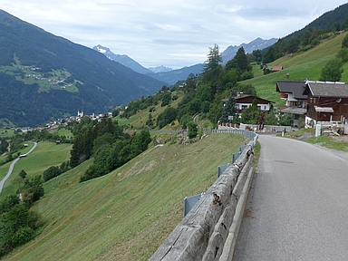

The ascent from Neuer Zoll am Inn to the Pillerhöhe is pretty steep. The first 5.5 of a total of 7.5 kilometers have an average slope of 10.0% without major deviations to higher or lower values. Two kilometers after the start, the road leads through a village (Fließ). Before and after Fließ houses and meadows skirt the road. This offers a wide view of the Inn Valley and of many mountains, including the striking Hoher Riffler (3,168 m) to the west, still (in 2019) marked by a small glacier. There are a total of 10 hairpin bends in the route. Before the ninth, the road enters into the forest and after the last hairpin bend the road is less steep (8-9%). Turn right at a fork (the Pillerhöhe itself). The destination is a little over 200 meters further ahead at the Naturparkhaus Kaunergrat.
Rijd op 21 maart deze prachtige tocht vanuit Wageningen over de Veluwe. Keuze uit 80 en 125 km met resp. 580 en 990 hoogtemeters. Inschrijving vanaf 31 december
Tour for Life
Rijdt deze zomer de unieke en klassieke 8-daagse wielrentocht van Noord-Italië naar Zuid-Nederland voor Artsen zonder Grenzen!