
Pillerhöhe-south
CyclingUp: Pillerhöhe-south
Climbing effort: 756 cep
Elevation meters: 758
Steepest kilometer: 14.2%
Steepest 250 m: 17%
Foot: 870 m Top: 1585 m
Mean slope: 6.8%
Length: 10.5 km
From: Prutz
Road conditions (2019): good
Other race bikers: 5-10 per hour
Motor vehicles: 30-60 per hour
Scenery and road:
Restaurant or bar near top: yes
PHOTOS
NE W SIDE Download gpx

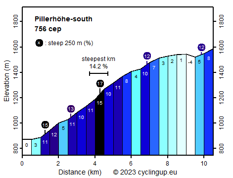
The climb from Prutz to the Pillerhöhe offers beautiful and wide views of the Inn Valley and of a large number of mountains all around. In addition, this climb offers some particularly steep sections. Among these the part beginning shortly before Kauns, after 2.5 kilometers of cycling, and ending shortly after Kaunerberg, is the most vicious. Here, during 3 kilometers 344 elevation meters are gained (average 11.5%) and the steepest kilometer (14.2%) in Austria on this website so far (2019) is found. After Kaunerberg still a distance of more than 5 kilometers must be covered to the highest point. First, the road gradually becomes less steep. There is a passage with lovely meadows and forests and even a descent where 38 elevation meters are lost. The last kilometer is then a little steeper (5-8%). The culmination point and thus the goal of the ride lie near the Naturparkhaus Kaunergrat, which is situated about 200 meters before reaching the Pillerhöhe itself.
Rijd op 22 maart deze prachtige tocht over de Veluwe, 75 of 125 kilometer vanuit Wageningen. Met veel hoogtemeters: resp. 550 en 970. Inschrijving
1K Ride
Rijd op 15 juni deze tocht met meer dan 1000 hoogtemeters; 80, 120 of 145 kilometer vanuit Oosterbeek. Inschrijving
Tour for Life
Rijdt deze zomer de unieke en klassieke 8-daagse wielrentocht van Noord-Italië naar Zuid-Nederland voor Artsen zonder Grenzen!