
Oberalppass-west
CyclingUp: Oberalppass-west
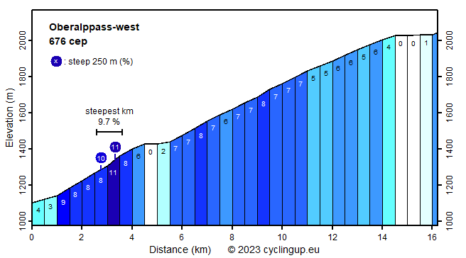
Climbing effort: 676 cep
Elevation meters: 947
Steepest kilometer: 9.7%
Steepest 250 m: 11%
Foot: 1102 m Top: 2044 m
Mean slope: 5.8%
Length: 16.2 km
From: Göschenen
Road conditions (2020): good
Other race bikers: 5-10 per hour
Motor vehicles: 60-180 per hour
Scenery and road:
Restaurant or bar near top: yes
PHOTOS Download gpx
The climb to the Oberalppass from the west
starts in Göschenen.
After a one kilometer long, easy approach (3-4%)
the route turns sharply to the right onto the main road.
Over the next three kilometers the ride continues
through a steep valley, which toward the end even becomes a gorge,
the so-called Schöllenen.
This was for a long time
an insurmountable obstacle for the construction
of a continuous road across the Gotthard,
until in 1198 the Teufelsbrücke (Devil's Bridge) was completed.
There is a lot of traffic in the Schöllenen (and there is a railway).
Fortunately, one may leave the road
after the fourth hairpin bend (which turns left)
and continue on a cycle path that is mostly
well separated from the road.
This path is often utterly steep, though never over a long distance.
Here lies the steepest kilometer of the entire trip (9.7%).
After the Schöllenen the next kilometer is almost horizontal.
In Andermatt, turn left towards the Oberalppass.
There remain still 600 meters in altitude to the pass.
Over the first five kilometers the road mostly has a gradient of 7%.
After that, the next three kilometers are easier (5-6%).
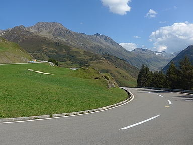
The pass is finally reached shortly after the elongated Oberalpsee.
I found the first few kilometers past Andermatt the most beautiful of the ride,
thanks to the views,
especially in a south-easterly direction of the Unteralptal
and in a westerly direction of the Urserental
and the mountains beyond.
The ascent suggested here can be extended
by beginning in Amsteg, from Göschenen further down in the Reussdal.
This would increase the distance by 16.2 kilometers,
the number of meters in altitude with 623
and the climbing effort by 357
climb effort points.
Rijd op 21 maart deze prachtige tocht vanuit Wageningen over de Veluwe. Keuze uit 80 en 125 km met resp. 580 en 990 hoogtemeters. Inschrijving vanaf 31 december
Tour for Life
Rijdt deze zomer de unieke en klassieke 8-daagse wielrentocht van Noord-Italië naar Zuid-Nederland voor Artsen zonder Grenzen!