
Lac de Moiry
CyclingUp: Lac de Moiry
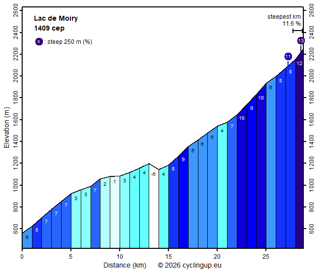
Climbing effort: 1409 cep
Elevation meters: 1791
Steepest kilometer: 11.6%
Steepest 250 m: 13%
Foot: 560 m Top: 2250 m
Mean slope: 5.9%
Length: 28.8 km
From: Sierre
Road conditions (2025): average
Other race bikers: 1-5 per hour
Motor vehicles: 30-60 per hour
Scenery and road:
Restaurant or bar near top: yes
PHOTOS Download gpx

During this climb from Sierre to the Lac de Moiry
I encountered only a few other cyclists,
as is often the case elsewhere in the Valais.
Is this because there are hardly any mountain passes here,
so circular routes are only scarcely possible?
Often riding up and down the same road
is the only option.
This also applies to the largest part of this ride
to the Lac de Moiry.
On the postive side: nature offers plenty of beauty
and there are demanding climbing sections.
The first 13 kilometres from Sierre to Vissoie
follow the busy road through the Val d’Anniviers,
which is also heavily used by lorries.
Even so, I found this section attractive,
thanks to the views of the Rhône valley
and the varied character of the road.
In the first five fairly steep kilometres (7–8%)
there is a section with six hairpin bends
following one another in quick succession.
On the stretch between the hamlet of Niouc and Vissoie,
relatively little elevation is gained
at an average gradient of 3.5%.
Here the road runs high above a gorge in the Val d’Anniviers
and has to deviate sideways twice
to cross side valleys.
The almost vertical walls of these side valleys
are impressive.
In Vissoie the route turns right,
and after a short descent
the road first climbs quite steeply (8–9%)
and then more gently (5–7%)
towards the tourist village of Grimentz.
At the end of Grimentz
the inhabited world is left behind,
and the ride becomes more exciting.
For four kilometres the road climbs steeply (9–11%).
At first there are two hairpin bends,
after which the road runs
in the longitudinal direction of the valley.
When coming around a corner after leaving the forest,
the gradient eases briefly
and the dam of the Lac de Moiry comes into view.
Further ahead you have to push harder again (8%),
and shortly before the dam
the road makes a wide turn to the left
The asphalt gets steep again with two 250-metre-segments of 11
and 12%, respectively.
Then you enter into a tunnel
with inside another 250-metre-segment at 12%.
Immediately after leaving the tunnel,
you are almost on top of the dam
and have reached the end of the climb.
I found the landscape between Grimentz
and the reservoir to be of outstanding beauty.
If you still have some energy left,
it is highly recommended
to continue riding along the lake
and then climb gently again for another kilometre
with about 50 metres of additional elevation gain.
The road ends with a magnificent view
of the Glacier de Moiry
at the foot of the Grand Cornier (3961 metres).
Rijd op 21 maart deze prachtige tocht vanuit Wageningen over de Veluwe. Keuze uit 80 en 125 km met resp. 580 en 990 hoogtemeters. Inschrijving vanaf 31 december
Tour for Life
Rijdt deze zomer de unieke en klassieke 8-daagse wielrentocht van Noord-Italië naar Zuid-Nederland voor Artsen zonder Grenzen!