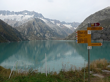
Göscheneralpsee

CyclingUp: Göscheneralpsee

Climbing effort: 602 cep
Elevation meters: 703
Steepest kilometer: 11.0%
Steepest 250 m: 13%
Foot: 1102 m Top: 1797 m
Mean slope: 7.1%
Length: 9.8 km
From: Göschenen
Road conditions (2020): good
Other race bikers: 0-1 per hour
Motor vehicles: 10-30 per hour
Scenery and road:
Restaurant or bar near top: yes
PHOTOS Download gpx

If you are in the region around Andermatt and you are looking for an alternative for the wide and busy roads that lead to well-known passes like the Gotthard and the Furka, then the climb from Göschenen to the Göscheneralpsee definitely is a good idea. The route is short (just under 10 kilometers) and runs on a quiet road, which for a mountain specialist is often pleasantly steep. Yet the first three kilometers are easy (2-4%), except for a 9% 500-meter segment just after the beginning. Though the first three kilometers may serve as a warm-up, the hardest part of the climb immediately follows after that: three kilometers with an average gradient of 9.8%. The last three kilometers then start at the campsite. In the beginning these are somewhat less steep (a kilometer of 7%) but towards the end the required effort gets hard again (9-10%). Finally cycle from the parking lot past the barrier up to the dam. This is the finish and one may enjoy the lake with the snow- and ice-covered mountain range of the Winterberg behind. Warning: bring illumination for one of the tunnels of this climb.


Rijd op 30 augustus deze prachtige klimtocht vanuit Wageningen over de Veluwe, door Montferland, Reichswald en Rijk van Nijmegen. Keuze uit 105 en 155 km met resp. 750 en 1130 hoogtemeters. Inschrijven vanaf 22 juni
Tour for Life
Rijdt deze zomer de unieke en klassieke 8-daagse wielrentocht van Noord-Italië naar Zuid-Nederland voor Artsen zonder Grenzen!

