
Col du Tourmalet-east
CyclingUp: Col du Tourmalet-east
Climbing effort: 1055 cep
Elevation meters: 1271
Steepest kilometer: 10.0%
Steepest 250 m: 11%
Foot: 847 m Top: 2115 m
Mean slope: 7.5%
Length: 16.9 km
From: Ste-Marie-de-Campan
Road conditions (2014): good
Other race bikers: 5-10 per hour
Motor vehicles: 60-180 per hour
Scenery and road:
Restaurant or bar near top: yes
PHOTOS VIDEO
W SIDE Download gpx

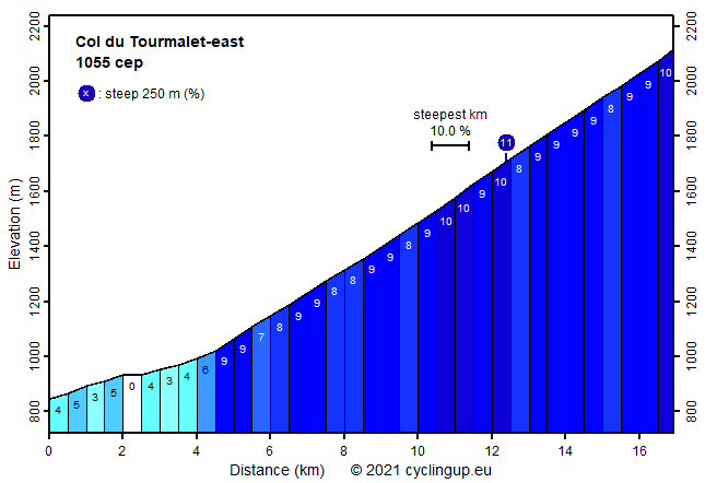
The Tourmalet is doubtless one of the most famous Tour de France cols. Anyway, it is the most climbed pass in the Tour (82 times until to 2012), thanks to the challenge it offers and its strategic position. The ascent from the eastern side is slightly steeper than the ascent from the western side. After the start in Ste-Marie de Campan the first four kilometers through the pleasant Vallée de Gripp are easy with the slope not exceeding 5%. Then, the road becomes steep, which remains the case for the 12 kilometers that lie ahead up to the col. Mostly the slope is 9% but there are some stretches of 10%. The longest one begins in the semi-open avalanche construction that one enters after a long serpentine into a side valley on the cyclist's left hand side. This 10% stretch ends in the ugly ski resort of La Mongie. The final few kilometers up to the pass are the most beautiful with views on grey and dark brown rough mountain faces. The slope is typically 9% again but the last 500 meters are a bit steeper.
Rijd op 21 maart deze prachtige tocht vanuit Wageningen over de Veluwe. Keuze uit 80 en 125 km met resp. 580 en 990 hoogtemeters. Inschrijving vanaf 31 december
Tour for Life
Rijdt deze zomer de unieke en klassieke 8-daagse wielrentocht van Noord-Italië naar Zuid-Nederland voor Artsen zonder Grenzen!