Pré de Madame Carle

CyclingUp: Pré de Madame Carle

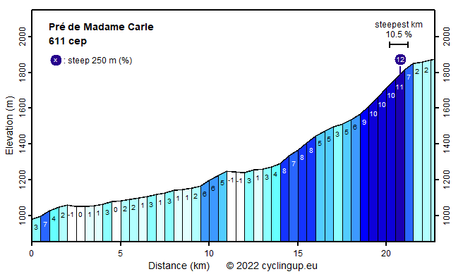
Climbing effort: 611 cep
Elevation meters: 929
Steepest kilometer: 10.5%
Steepest 250 m: 12%
Foot: 979 m Top: 1874 m
Mean slope: 3.9%
Length: 22.7 km
From: Argentière-la-Bessée
Road conditions (2013): moderate
Other race bikers: 5-10 per hour
Motor vehicles: 60-180 per hour
Scenery and road:
Restaurant or bar near top: yes
PHOTOS Download gpx

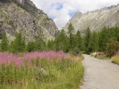
The best reason to bike to the Pré de Madame Carle are the final 5 kilometers after the passage of Ailefroide. A largely steep (~10%) and narrow road climbs up a superbly beautiful valley. The forest here is sparse enough to enable views on the surroundings mountains, the verge of the road is full of purple flowers and towards the end of the tour Glacier Blanc can be seen (in 2013!). Unfortunately for cyclists this glacier is, on sunny summer days, the aim for many tourists with their cars. The tour starts at the bridge over the Durance in l'Argentière-la-Bessée and follows the busy D994e until Vallouise. Biking becomes nicer after Vallouise when several villages skirt the road. After driving through a short tunnel true climbing begins with a 2 kilometer long section of moderate steepness (8%) followed by an easier part until Ailefroide. The most beautiful and challenging part then completes the climb.


Rijd op 22 maart deze prachtige tocht over de Veluwe, 75 of 125 kilometer vanuit Wageningen. Met veel hoogtemeters: resp. 550 en 970. Inschrijving
1K Ride
Rijd op 15 juni deze tocht met meer dan 1000 hoogtemeters; 80, 120 of 145 kilometer vanuit Oosterbeek. Inschrijving
Tour for Life
Rijdt deze zomer de unieke en klassieke 8-daagse wielrentocht van Noord-Italië naar Zuid-Nederland voor Artsen zonder Grenzen!

