
Peisey-Nancroix
CyclingUp: Peisey-Nancroix
Climbing effort: 630 cep
Elevation meters: 824
Steepest kilometer: 9.4%
Steepest 250 m: 12%
Foot: 730 m Top: 1550 m
Mean slope: 6.4%
Length: 12.7 km
From: Landry
Road conditions (2018): moderate
Other race bikers: 1-5 per hour
Motor vehicles: 60-180 per hour
Scenery and road:
Restaurant or bar near top: yes
PHOTOS Download gpx

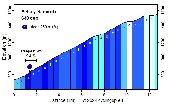
I found the road surface the most remarkable aspect of this climb. Its condition was miserable, at least in 2018. The total number of elevation meters is quite limited (824). which helps to make the climb not really difficult. The trip begins along the D87, at the bridge over the Isère, just north of Landry. At the end of this village, after a kilometer cycling, the road enters the forest, which will not be left for the next six kilometers. This is the most difficult part of the climb with an average gradient of 8.1% and the steepest kilometer of the tour (9.4%), found at the beginning of this section. We leave the forest in the village of Peisey-Nancroix. From here the ascent becomes easier (0-8%) and the busy street is slowly becoming more quiet. A beautiful view of some peaks of the Vanoise, including the Dôme de la Sache (3588 m), unfolds in front of the cyclist.
Rijd op 21 maart deze prachtige tocht vanuit Wageningen over de Veluwe. Keuze uit 80 en 125 km met resp. 580 en 990 hoogtemeters. Inschrijving vanaf 31 december
Tour for Life
Rijdt deze zomer de unieke en klassieke 8-daagse wielrentocht van Noord-Italië naar Zuid-Nederland voor Artsen zonder Grenzen!