
Col du Mollard-southwest
CyclingUp: Col du Mollard-southwest
Climbing effort: 998 cep
Elevation meters: 1245
Steepest kilometer: 9.9%
Steepest 250 m: 11%
Foot: 549 m Top: 1638 m
Mean slope: 5.2%
Length: 21.0 km
From: St-Jean-de-Maurienne
Road conditions (2018): average
Other race bikers: 5-10 per hour
Motor vehicles: 30-60 per hour
Scenery and road:
Restaurant or bar near top: yes
PHOTOS
NW NE SIDE Download gpx

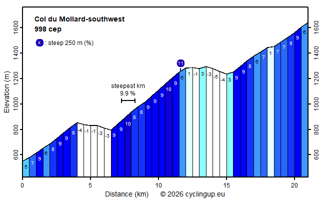
From Saint-Jean-de-Maurienne and its surroundings there are three ways to ride up to the Col du Mollard. Among these, the route described here, which initially coincides with the ascent to the Col de la Croix de Fer along the D926, is the hardest (998 climb effort points). This is mainly due to two descents on the D926, so some metres of elevation have to be gained twice. The ride begins with about 4 kilometres of climbing (5–9%) up to the junction of the road to La Toussuire. This is followed by a section that is mostly downhill (a net loss of 63 metres of elevation). After that, the road climbs along the orographically left side of the gorge-like Arvan valley — a section of more than 5 kilometres with 470 metres of elevation gain (8–10%). This is the most demanding part of the ascent. Next comes an almost horizontal section with three well-lit tunnels, followed by another descent of 63 metres of elevation. After this descent, this climb leaves the D926 by taking the turn-off towards Albiez-le-Vieux. From here on, traffic, which has been quite dense up to this point, is fortunately much lighter. At first the road climbs quite steeply (9%), but after that cycling becomes somewhat easier. The final 3 kilometres are the most beautiful of the entire route, because the more open landscape hardly restricts the view. Impressive are, to the south, the steep, sharp peaks of the Aiguilles d’Arves (3510 metres) and, to the west, the snow- and ice-covered Grandes Rousses (3468 metres).
Rijd op 21 maart deze prachtige tocht vanuit Wageningen over de Veluwe. Keuze uit 80 en 125 km met resp. 580 en 990 hoogtemeters. Inschrijving vanaf 31 december
Tour for Life
Rijdt deze zomer de unieke en klassieke 8-daagse wielrentocht van Noord-Italië naar Zuid-Nederland voor Artsen zonder Grenzen!