
Col des Aravis-southeast
CyclingUp: Col des Aravis-southeast
Climbing effort: 405 cep
Elevation meters: 613
Steepest kilometer: 7.9%
Steepest 250 m: 9%
Foot: 906 m Top: 1486 m
Mean slope: 5.0%
Length: 11.6 km
From: Flumet
Road conditions (2019): good
Other race bikers: 5-10 per hour
Motor vehicles: 60-180 per hour
Scenery and road:
Restaurant or bar near top: yes
PHOTOS
NW SIDE Download gpx
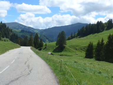
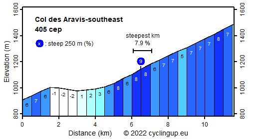
The Col des Aravis is popular among car drivers, motorcyclists and cyclists, partly because it is one of the cols of the Route des Grandes Alpes. Maybe tourists also visit this pass because it offers impressive views of the peaks of the Mont Blanc massif, at least when the famous mountain is not hiding behind clouds. Due to its popularity, the pass itself is quite hectic with many restaurants and shops. This ascent begins in Flumet at the beautiful bridge over the Arly. The road is moderately steep (6-7%) for the first one and a half kilometers. This is followed by three kilometers, in which the road runs almost horizontally. A kilometer before La Giettaz the road starts to rise again considerably. This then remains the case over the remaining seven kilometers (mostly 6-8%). The steepest kilometer (7.9%) starts in the center of La Giettaz.
Rijd op 21 maart deze prachtige tocht vanuit Wageningen over de Veluwe. Keuze uit 80 en 125 km met resp. 580 en 990 hoogtemeters. Inschrijving vanaf 31 december
Tour for Life
Rijdt deze zomer de unieke en klassieke 8-daagse wielrentocht van Noord-Italië naar Zuid-Nederland voor Artsen zonder Grenzen!