
Col de la Moutière-east
CyclingUp: Col de la Moutière-east
Climbing effort: 1037 cep
Elevation meters: 1300
Steepest kilometer: 12.2%
Steepest 250 m: 15%
Foot: 1144 m Top: 2438 m
Mean slope: 7.1%
Length: 18.3 km
From: St-Étienne-de-Tinée
Road conditions (2020): bad
Other race bikers: 1-5 per hour
Motor vehicles: <10 per hour
Scenery and road:
Restaurant or bar near top: no
PHOTOS Download gpx
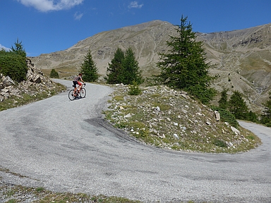
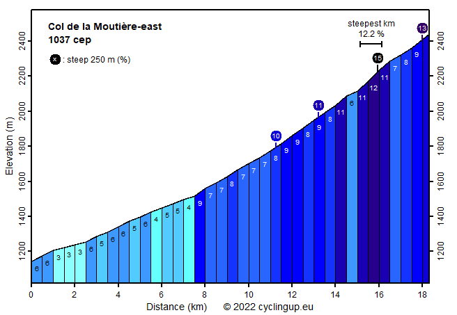
The climb to the Col de la Moutière from St-Étienne-de-Tinée is the little brother of the climb to the Col de la Bonette from the same village. Until Pont Haut, which is reached after a little more than 4 kilometers and about 200 meters in altitude, the two climbs follow the same road. Past Pont Haut, the route to the Moutière runs parallel to and more southerly than the road to its big brother. The ascent to the Moutière counts 362 elevation meters and 150 climb effort points less than the ascent to the Bonette, and follows a much narrower road with much less traffic and a miserable pavement. The landscape is impressive. The first 3 kilometers from Pont Haut to St-Delmas-le-Selvage are still easy (4-6%), with a beautiful, steep and dark mountain range in the background. Then the road leads into the forest and the 500 meter segments gradually become steeper, initially mostly 7%, later mostly 9% with peak values of up to 11%. At Sestrière Basse, at an altitude of 2000 meters, one gets into a more open landscape. The alpine meadows and the views are superb. A little further a number of hairpin bends mark the hardest part of the climb, a kilometer of 12.2% and a strip of 250 meters of 15%. After that, there remain 2 kilometers to the pass, which is not signposted. After the pass it is possible to continue on a dirt road, which descends first and then climbs to the road from the Bonette to Jausiers.
Rijd op 21 maart deze prachtige tocht vanuit Wageningen over de Veluwe. Keuze uit 80 en 125 km met resp. 580 en 990 hoogtemeters. Inschrijving vanaf 31 december
Tour for Life
Rijdt deze zomer de unieke en klassieke 8-daagse wielrentocht van Noord-Italië naar Zuid-Nederland voor Artsen zonder Grenzen!