
Col de la Croix Fry-west
CyclingUp: Col de la Croix Fry-west
Climbing effort: 625 cep
Elevation meters: 811
Steepest kilometer: 10.4%
Steepest 250 m: 11%
Foot: 648 m Top: 1459 m
Mean slope: 6.9%
Length: 11.7 km
From: Thônes
Road conditions (2019): good
Other race bikers: 10-25 per hour
Motor vehicles: 10-30 per hour
Scenery and road:
Restaurant or bar near top: yes
PHOTOS
E SIDE Download gpx
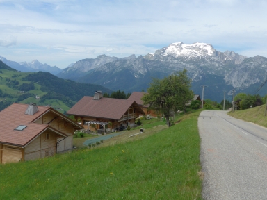

The mountain ranges around Thônes and La Clusaz are not very high but steep and beautiful. The valleys are particularly green but also densely populated. As a result, the roads in this region are often relatively busy. All of these features can be found along the road from Thônes to the Col de la Croix Fry. The ascent begins on the road connecting Thônes to Faverges (D12), namely at the junction to Manigod and the pass. The first three kilometers are moderately steep (6-9%). Then, before and in Manigod, two easy kilometers follow (2-6%). The real work begins right after Manigod. The first two kilometers after Manigod are particularly hard with an average gradient of 9.5%. Then, while approaching the pass, the asphalt gradually becomes less steep. Because in the second part of the trip the road is surrounded by fields and houses, there is a wide view in southerly and westerly directions (La Tournette, 2351 m).
Rijd op 21 maart deze prachtige tocht vanuit Wageningen over de Veluwe. Keuze uit 80 en 125 km met resp. 580 en 990 hoogtemeters. Inschrijving vanaf 31 december
Tour for Life
Rijdt deze zomer de unieke en klassieke 8-daagse wielrentocht van Noord-Italië naar Zuid-Nederland voor Artsen zonder Grenzen!