Col de la Croix Fry-east

CyclingUp: Col de la Croix Fry-east

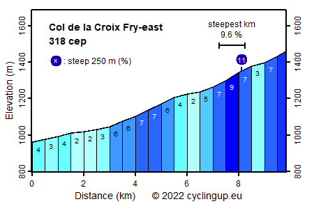
Climbing effort: 318 cep
Elevation meters: 505
Steepest kilometer: 9.6%
Steepest 250 m: 11%
Foot: 959 m Top: 1459 m
Mean slope: 5.1%
Length: 9.8 km
From: St-Jean-de-Sixt
Road conditions (2019): good
Other race bikers: 10-25 per hour
Motor vehicles: 30-60 per hour
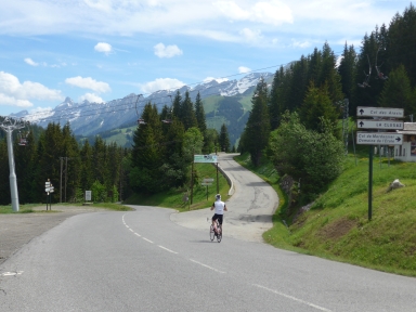
Scenery and road:
Restaurant or bar near top: yes
PHOTOS
W SIDE Download gpx

To begin, this climb from St-Jean-de-Sixt to the Col de la Croix Fry
follows the D909 towards the Col des Aravis.
There is heavy traffic on the first three kilometers to La Clusaz.
After that there is less traffic on the
road, which becomes somewhat steeper (6-7%).
At two and a half kilometers past La Clusaz,
we turn right towards the Col de la Croix Fry.
One kilometer further ahead, the most pleasant
part of the trip begins,
partly because the climb finally leaves the built-up area.
To the pass still three kilometers remain.
The first of these is the steepest (9.6%).
The climb can be extended with the ride from Thônes
to St-Jean-de-Sixt.
That adds another 164
climb effort points (cep) and 332 elevation meters.
Unfortunately, this extension takes place on a road
with a lot of fast driving traffic in an unimpressive landscape.


Rijd op 22 maart deze prachtige tocht over de Veluwe, 75 of 125 kilometer vanuit Wageningen. Met veel hoogtemeters: resp. 550 en 970. Inschrijving
1K Ride
Rijd op 15 juni deze tocht met meer dan 1000 hoogtemeters; 80, 120 of 145 kilometer vanuit Oosterbeek. Inschrijving
Tour for Life
Rijdt deze zomer de unieke en klassieke 8-daagse wielrentocht van Noord-Italië naar Zuid-Nederland voor Artsen zonder Grenzen!

