
Col de la Bonette-southeast
CyclingUp: Col de la Bonette-southeast
Climbing effort: 1187 cep
Elevation meters: 1662
Steepest kilometer: 11.3%
Steepest 250 m: 14%
Foot: 1144 m Top: 2802 m
Mean slope: 6.5%
Length: 25.4 km
From: St-Étienne-de-Tinée
Road conditions (2020): good
Other race bikers: 10-25 per hour
Motor vehicles: 60-180 per hour
Scenery and road:
Restaurant or bar near top: no
PHOTOS
N SIDE Download gpx

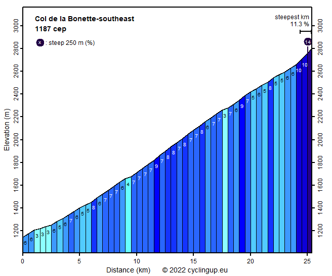
The Col de la Bonette (2715 m) is the fourth highest pass in the Alps. From the pass itself a road loops around a mountain top (Cime de la Bonette). This loop reaches an elevation of 2802 meters making this road the third highest paved road in Europe. Claiming that this is the highest route in Europe, as it is written on signs posted along the road, is therefore wrong. That doesn't change the fact that the ascent from St-Étienne-de-Tinée is strenuous. Altogether there are 1658 elevation meters between start and finish, a considerable part of which must be overcome in relatively thin air. Fortunately, the road is almost nowhere very steep. Only four 500 meter segments have a slope larger than 8%. The most difficult section is between the the pass and the highest point of the loop, that is, if you keep to the left at the pass (one kilometer of 11.3%). The landscape is superb. The first 8 to 9 kilometers are dominated by green vegetation. After that there are great views of rugged mountain ranges with peaks up to approx. 3000 meters but unfortunately without snow, at least when I was here.
Rijd op 21 maart deze prachtige tocht vanuit Wageningen over de Veluwe. Keuze uit 80 en 125 km met resp. 580 en 990 hoogtemeters. Inschrijving vanaf 31 december
Tour for Life
Rijdt deze zomer de unieke en klassieke 8-daagse wielrentocht van Noord-Italië naar Zuid-Nederland voor Artsen zonder Grenzen!