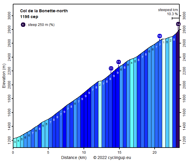
Col de la Bonette-north

CyclingUp: Col de la Bonette-north

Climbing effort: 1195 cep
Elevation meters: 1587
Steepest kilometer: 10.3%
Steepest 250 m: 14%
Foot: 1224 m Top: 2802 m
Mean slope: 6.7%
Length: 23.5 km
From: Jausiers
Road conditions (2013): good
Other race bikers: 10-25 per hour
Motor vehicles: 10-30 per hour
Scenery and road:
Restaurant or bar near top: no
PHOTOS
SE SIDE Download gpx

This climb brings the race biker to one of the highest cols of the Alps (2715 m) and from there to the second highest paved road in the Alps (2802 m). Accordingly, the elevation difference is considerable (almost 1600 m). The tour begins in Jausiers at the bifurcation of the D900 and the D64. The climb is never boring, has a number of parts with hair pin turns. Up to the pass the slope is quite regular with many stretches of 8-9%. Three times one encounters a section of 250 meters with a slope of 10 or 11%. Early in summer snow covers most of the surroundings in the upper part of the climb. The bonus is the loop around the Cime de la Bonette (2860 m) from the pass, of which only the eastern part was free of snow when I made the climb. It is pretty steep (up to 13%) and brings the cyclist up to 2802 m. Views from the loop are superb. The tour is popular among cyclists, cars are scarce and road conditions generally good.


Rijd op 22 maart deze prachtige tocht over de Veluwe, 75 of 125 kilometer vanuit Wageningen. Met veel hoogtemeters: resp. 550 en 970. Inschrijving
1K Ride
Rijd op 15 juni deze tocht met meer dan 1000 hoogtemeters; 80, 120 of 145 kilometer vanuit Oosterbeek. Inschrijving
Tour for Life
Rijdt deze zomer de unieke en klassieke 8-daagse wielrentocht van Noord-Italië naar Zuid-Nederland voor Artsen zonder Grenzen!

