
-northeast
CyclingUp: -northeast
Climbing effort: cep
Elevation meters:
Steepest kilometer: %
Steepest 250 m: %
Foot: m Top: m
Mean slope: %
Length: km
From:
Road conditions ():
Other race bikers: per hour
Motor vehicles: per hour
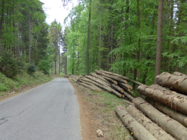
Scenery and road:
Restaurant or bar near top:
PHOTOS VIDEO Download gpx
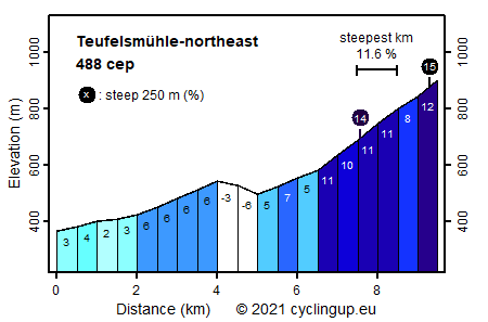
Far in the north of the Black Forest, there are two climbs with a considerable number of climb effort points, or cep, namely two options to drive to the top of the Teufelsmühle. From the northeast, starting in Bad Herrenalb, the climb is easier (488 cep) than from the west (Start in Gernsbach, 608 cep). This difference is due to the number the elevation meters (736 for the western and 581 for the northeastern climb). The first five kilometers from the Bad Herrenalb side run over the L564, a busy street connecting Bad Herrenalb with Gernsbach. With a maximum of 6%, the road is nowhere steep in this part. The highest point of this road is reached after four kilometers (in Käppele). Then, on the other side it goes down 50 elevation meters over a distance of a kilometer before turning left onto a very quiet side street. From here, follow the signs to Teufelsmühle. The first kilometer on the side street is still easy (5-6%) but then, from the Rißwasenhütte, the road becomes steep. Most of the remaining three kilometers tilt 9-11%. Slightly less than a kilometer before the end the slope decreases a bit but the final ramp, including a section of 250 meters of 15%, is substantial.
Rijd op 21 maart deze prachtige tocht vanuit Wageningen over de Veluwe. Keuze uit 80 en 125 km met resp. 580 en 990 hoogtemeters. Inschrijving vanaf 31 december
Tour for Life
Rijdt deze zomer de unieke en klassieke 8-daagse wielrentocht van Noord-Italië naar Zuid-Nederland voor Artsen zonder Grenzen!