Eduardshöhe-north

CyclingUp: Eduardshöhe-north

Climbing effort: 468 cep
Elevation meters: 600
Steepest kilometer: 11.5%
Steepest 250 m: 14%
Foot: 280 m Top: 859 m
Mean slope: 5.0%
Length: 11.7 km
From: Freiburg
Road conditions (2015): good
Other race bikers: 5-10 per hour
Motor vehicles: 30-60 per hour
Scenery and road:
Restaurant or bar near top: no
PHOTOS
NW SIDE Download gpx

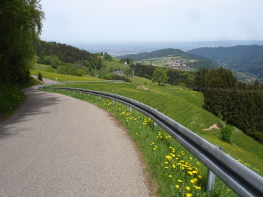
This ascent to the Eduardshöhe combines the first part of the North ascent from Freiburg to Schauinsland with the final part of the North-west ascent from Au to the Eduardshöhe. In between lies a connecting part of two kilometers long. My preferred ride to the Eduardshöhe in the one from Au because beginning from Freiburg one misses the most beautiful and difficult section of the ascent from Au. However, it may be an advantage that the start of the North ascent is located almost in the heart of Freiburg. The trip begins at the foot of the Johanneskirche. The first six kilometer head almost straight southward to Bohrer and form a pleasant warming up (0-5%). At Bohrer one leaves the popular ascent to Schauinsland and the above-mentioned connection follows. It is moderately steep (7-9%) and brings the biker on a wide road to Langackern, where a nearly horizontal section waits until the end of the village Horben. Upon leaving this last village, a very steep section (a kilometer of 11.6%) begins. On passing the Buckhof one can relax a little, before going into the tough (average slope 10%) final one and a half kilometers. Here the road is inaccessible to cars.


Rijd op 30 augustus deze prachtige klimtocht vanuit Wageningen over de Veluwe, door Montferland, Reichswald en Rijk van Nijmegen. Keuze uit 105 en 155 km met resp. 750 en 1130 hoogtemeters. Inschrijven vanaf 22 juni
Tour for Life
Rijdt deze zomer de unieke en klassieke 8-daagse wielrentocht van Noord-Italië naar Zuid-Nederland voor Artsen zonder Grenzen!

