
Furx
CyclingUp: Furx
Climbing effort: 616 cep
Elevation meters: 670
Steepest kilometer: 11.3%
Steepest 250 m: 12%
Foot: 470 m Top: 1140 m
Mean slope: 8.2%
Length: 8.2 km
From: Rankweil
Road conditions (2022): excellent
Other race bikers: 1-5 per hour
Motor vehicles: 10-30 per hour
Scenery and road:
Restaurant or bar near top: yes
PHOTOS Download gpx
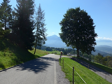

Furx is a small settlement east of Rankweil and is dominated by a restaurant and its parking lot. On the terrace you can recover after the effort of the climb from Rankweil. The ride does not bridge an impressive number of meters in altitude (670) but it is, typically Austrian, quite steep. The first 3.5 kilometers on the L51 shares this climb with the much longer climb to the Furkajoch and the gradient is still relatively small (2-7%). In Batschuns the two ascents separate, we turn left and about a hundred meters further on we turn right. Soon the fairly wide road becomes steep and this remains the case for the next 4.5 kilometers. This part has an average slope of 10.2%. Only the last few hundred meters before Furx are a little easier. On the way you have views of the mountains on the other side of the Rhine Valley, including the Alpstein (Säntis).
Rijd op 21 maart deze prachtige tocht vanuit Wageningen over de Veluwe. Keuze uit 80 en 125 km met resp. 580 en 990 hoogtemeters. Inschrijving vanaf 31 december
Tour for Life
Rijdt deze zomer de unieke en klassieke 8-daagse wielrentocht van Noord-Italië naar Zuid-Nederland voor Artsen zonder Grenzen!