Eisentalhöhe-northwest

CyclingUp: Eisentalhöhe-northwest

Climbing effort: 753 cep
Elevation meters: 1094
Steepest kilometer: 9.0%
Steepest 250 m: 11%
Foot: 957 m Top: 2042 m
Mean slope: 6.1%
Length: 17.7 km
From: Kremsbrücke
Road conditions (2019): good
Other race bikers: 5-10 per hour
Motor vehicles: 60-180 per hour
Scenery and road:
Restaurant or bar near top: yes
PHOTOS
SE SIDE Download gpx

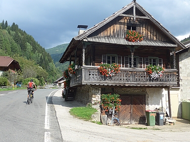
The ascent from Kremsbrücke to the Eisentalhöhe can be divided into two parts, namely the first section along the Kremsbach to Innerkrems and a steeper part afterwards. The first part has a considerable length (9.5 kilometers) and overcomes 517 elevation meters. Hence, the average gradient measures 5.4%. I found the first kilometers of this climb, through a narrow valley and through Vorderkrems with its magnificent, flower-rich farms, surprisingly beautiful. After Innerkrems the tour continues on the Nockalmstraße, a tourist attraction. In my opinion it's a pretty nice road but I've seen better ones. The road is not really calm and loved by motorcyclists. The surrounding area is full of nature but not spectacular. Also, the road is wide and the slope of the climb from the northwest to the Eisentalhöhe is fairly constant (around 8%), which makes cycling a bit boring. Views are limited to the last 3-4 kilometers.


Rijd op 22 maart deze prachtige tocht over de Veluwe, 75 of 125 kilometer vanuit Wageningen. Met veel hoogtemeters: resp. 550 en 970. Inschrijving
1K Ride
Rijd op 15 juni deze tocht met meer dan 1000 hoogtemeters; 80, 120 of 145 kilometer vanuit Oosterbeek. Inschrijving
Tour for Life
Rijdt deze zomer de unieke en klassieke 8-daagse wielrentocht van Noord-Italië naar Zuid-Nederland voor Artsen zonder Grenzen!

