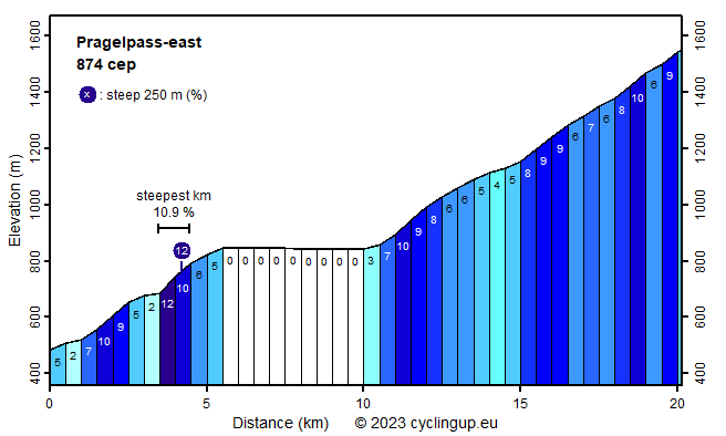
Pragelpass-east

CyclingUp: Pragelpass-east

Climbing effort: 874 cep
Elevation meters: 1082
Steepest kilometer: 10.9%
Steepest 250 m: 12%
Foot: 482 m Top: 1548 m
Mean slope: 5.3%
Length: 20.1 km
From: Netstal
Road conditions (2023): average
Other race bikers: >25 per hour
Motor vehicles: <10 per hour
Scenery and road:
Restaurant or bar near top: yes
PHOTOS Download gpx

This climb to the Pragelpass from Netstal (near Glarus), located east of the pass, takes place in a long valley. The mountain range on the left of the valley when climbing is impressively steep, especially in the first half of the ride. The highest peak in this chain is Vrenelisgärtli (2905 m). Between these mountains and the road lies the beautiful Klöntalersee, a reservoir. The climb can be divided into three parts. The first ends after more than 5 kilometers of cycling at the beginning of the Klöntalersee. In this part, 362 meters in altitude are overcome. There are some quite steep sections, including the steepest kilometer of the entire ascent (10.9%), which begins after 3.5 kilometers of cycling. The second part of the ride has a length of five kilometers and leads without much effort along the banks of the reservoir. The last part is the hardest job because it contains the largest number of meters in altitude (still 704). The gradient varies a lot (4-10% for the 500 meter segments). There were few cars on the very narrow street as I cycled up here, thanks to the closure for motorized vehicles (only in weekends, in 2023).


Rijd op 30 augustus deze prachtige klimtocht vanuit Wageningen over de Veluwe, door Montferland, Reichswald en Rijk van Nijmegen. Keuze uit 105 en 155 km met resp. 750 en 1130 hoogtemeters. Inschrijven vanaf 22 juni
Tour for Life
Rijdt deze zomer de unieke en klassieke 8-daagse wielrentocht van Noord-Italië naar Zuid-Nederland voor Artsen zonder Grenzen!

