Fideriser Heuberge

CyclingUp: Fideriser Heuberge

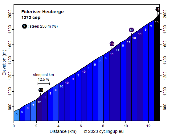
Climbing effort: 1272 cep
Elevation meters: 1258
Steepest kilometer: 12.5%
Steepest 250 m: 18%
Foot: 743 m Top: 2001 m
Mean slope: 9.7%
Length: 13.0 km
From: Fideris Bahnhof
Road conditions (2020): bad
Other race bikers: 0-1 per hour
Motor vehicles: <10 per hour
Scenery and road:
Restaurant or bar near top: yes
PHOTOS Download gpx

Warning: the road of this climb is
unpaved over, in total, a distance of approx. 1 km.
There are three unpaved sections
all located in the first half of the route.
Not only these unpaved sections are an issue.
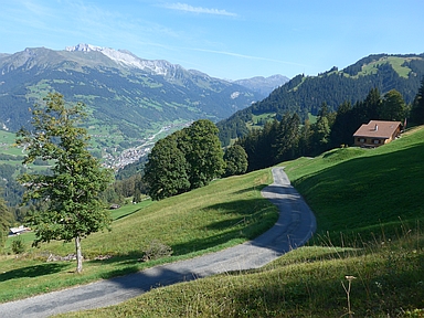
Almost the entire climb from the train station at Fideris
to the Fideriser Heuberge takes place on a bad road surface.
To compensate, the road is exciting and narrow,
there is hardly any traffic,
one can enjoy beautiful views in northerly directions
and the slope is steep.
The first two kilometers until the village of Fideris
are still relatively easy (6-9%)
but the remaining just over eleven kilometers
have an average slope of 10%.
In Fideris itself the hard work starts immediately
with the steepest kilometer of the ride (12.5%).
Then, over the next 5 kilometers,
the gradient fluctuates mostly between 9 and 10%.
However, when the road begins to run southward
in an almost straight line,
cycling becomes even more strenuous
with an average gradient of 10.5%.
Then a relatively easy kilometer (9%) follows.
At the bifurcation in the road just before the end you should then
keep right towards hotel Arflina.
The last 75 meters before the finish at this hotel
include a 250 meters section of 18%
with a deplorable road surface.


Rijd op 30 augustus deze prachtige klimtocht vanuit Wageningen over de Veluwe, door Montferland, Reichswald en Rijk van Nijmegen. Keuze uit 105 en 155 km met resp. 750 en 1130 hoogtemeters. Inschrijven vanaf 22 juni
Tour for Life
Rijdt deze zomer de unieke en klassieke 8-daagse wielrentocht van Noord-Italië naar Zuid-Nederland voor Artsen zonder Grenzen!

