HOME cyclingup.eu

regions

method
contact
links
French Alps
Switzerland
Austria
Italian Alps
French Pyrenees
Spain
Gran Canaria
Vosges
Black Forest
Brocken, Germany
Ardennes
Netherlands
Berninapass-northwest
CyclingUp: Berninapass-northwest
Climbing effort: 281 cep
Elevation meters: 603
Steepest kilometer: 7.2%
Steepest 250 m: 9%
Foot: 1728 m Top: 2328 m
Mean slope: 3.4%
Length: 17.8 km
From: Pontresina
Road conditions (2016): excellent
Other race bikers: 10-25 per hour
Motor vehicles: >180 per hour
Scenery and road:
Restaurant or bar near top: yes
PHOTOS VIDEO
S SIDE Download gpx
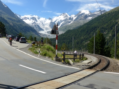

The ascent to the Berninapaß from Pontresina is certainly not hard. There are merely 603 elevation meters and only 3 out of a total of 18 kilometers is steeper than 5%. The steepest kilometer (7.2%) is located after Lagalb (after 14 kilometers cycling) on a straight section of the road without trees in the surroundings so the slope can easily be underestimated here. The climb is characterised by both ugliness and beauty. Ugly are the wide road full of cars and motorcycles, the high-voltage lines, the banks of a reservoir and the railway track. Extreme beauty is offered to the climbing cyclist on the right hand side with a view of the Morteratsch glacier and the surrounding mountain giants, including Piz Bernina (4049 m).
Veluviatocht
Rijd op 21 maart deze prachtige tocht vanuit Wageningen over de Veluwe. Keuze uit 80 en 125 km met resp. 580 en 990 hoogtemeters. Inschrijving vanaf 31 december
Tour for Life
Rijdt deze zomer de unieke en klassieke 8-daagse wielrentocht van Noord-Italië naar Zuid-Nederland voor Artsen zonder Grenzen!