
Alto de Trevélez-east
CyclingUp: Alto de Trevélez-east
Climbing effort: 383 cep
Elevation meters: 714
Steepest kilometer: 7.6%
Steepest 250 m: 9%
Foot: 1165 m Top: 1535 m
Mean slope: 1.6%
Length: 22.9 km
From: Cádiar
Road conditions (2019): excellent
Other race bikers: 1-5 per hour
Motor vehicles: 10-30 per hour
Scenery and road:
Restaurant or bar near top: no
PHOTOS Download gpx

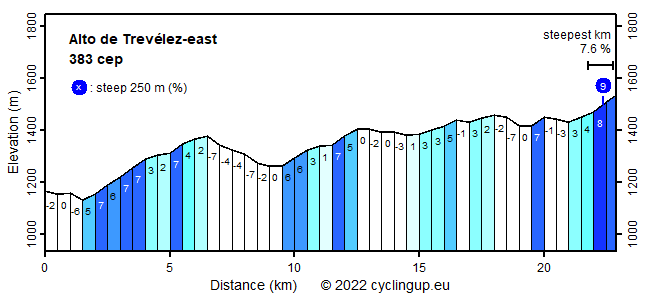
Along the southern edge of the Sierra Nevada, from Laroles to Órgiva, a road (A4130 and A4132) that cyclists should not miss runs from east to west. It is a quiet road, mostly lying far above the lowest part of a broad valley running in the same direction as the road. Wide views across the valley in a southerly direction, on the Sierra de la Contraviesa and the Sierra de Gádor, are impressive. Nice are the numerous white villages with small-scale tourism skirting the road. The vegetation in and around the villages is often quite exuberant while between the villages dry and green alternate rapidly. The region is called the Alpujarras and was the last refuge of the Moors after the fall of the Kingdom of Granada in 1492. The section of this road through the Alpujarras starting at the junction a few kilometers south-east of Bérchules until about a kilometer south-south-west of Trevélez brings the cyclist a net gain of 370 meters of elevation. However, there are also quite some descents within this section, so one has to climb 714 meters, totally. Nowhere the road of this section is really steep. Only the final kilometer contains a 500 meter interval with a slope greater than 7%.
For tours in the splendid and varied nature of Asturias.
Grazalema Cycling Adventures offers guided bike tours and rents road, mountain and electric bikes in splendid Andalusia.
Camping Alpujarras in Laroles, along the road to the Puerto de la Ragua, offers superb views, green grass, good meals and great hospitality.
Rijd op 22 maart deze prachtige tocht over de Veluwe, 75 of 125 kilometer vanuit Wageningen. Met veel hoogtemeters: resp. 550 en 970. Inschrijving
1K Ride
Rijd op 15 juni deze tocht met meer dan 1000 hoogtemeters; 80, 120 of 145 kilometer vanuit Oosterbeek. Inschrijving
Tour for Life
Rijdt deze zomer de unieke en klassieke 8-daagse wielrentocht van Noord-Italië naar Zuid-Nederland voor Artsen zonder Grenzen!