Vinschgauer Höhenstraße-east

CyclingUp: Vinschgauer Höhenstraße-east

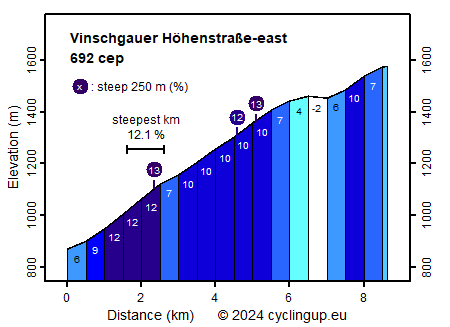
Climbing effort: 692 cep
Elevation meters: 719
Steepest kilometer: 12.1%
Steepest 250 m: 13%
Foot: 869 m Top: 1579 m
Mean slope: 8.2%
Length: 8.6 km
From: Laas
Road conditions (2023): average
Other race bikers: 0-1 per hour
Motor vehicles: 10-30 per hour
Scenery and road:
Restaurant or bar near top: no
PHOTOS
W SIDE Download gpx

The Vinschgauer Höhenstraße runs along the valley of the Vinschgau (in Italian Val Venosta), on the north slope and several hundred meters above the deepest part of the valley. The start and end points are the villages of Schluderns (Sluderno) und Laas (Lasa). I found the climb from the east (Laas) described here not as nice as that from the west. The road is wider and the views are more limited. On the other hand, the ascent from Lasa is tougher than the climb from Schluderns, as indicated by the number of climb effort points, 692 and 507, respectively. After the relatively easy first 500 meters (6%), the following 5 kilometers have an average gradient of 10.1% including a steepest kilometer at 12.1%. After these 5 kilometers there are still 3 kilometers left to the highest point of the road (at the turnoff to Unterfrini), which are easier (-2 to 10%). Here one may enjoy the view of the Vinschgau with its fruit trees against a background of numerous mountain peaks.


Rijd op 30 augustus deze prachtige klimtocht vanuit Wageningen over de Veluwe, door Montferland, Reichswald en Rijk van Nijmegen. Keuze uit 105 en 155 km met resp. 750 en 1130 hoogtemeters. Inschrijven vanaf 22 juni
Tour for Life
Rijdt deze zomer de unieke en klassieke 8-daagse wielrentocht van Noord-Italië naar Zuid-Nederland voor Artsen zonder Grenzen!

