
Val de la Mare
CyclingUp: Val de la Mare
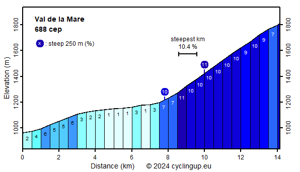
Climbing effort: 688 cep
Elevation meters: 855
Steepest kilometer: 10.4%
Steepest 250 m: 11%
Foot: 962 m Top: 1812 m
Mean slope: 6.0%
Length: 14.1 km
From: Cusiano
Road conditions (2023): average
Other race bikers: 1-5 per hour
Motor vehicles: 10-30 per hour
Scenery and road:
Restaurant or bar near top: no
PHOTOS Download gpx

A request:
Thanks to a solid fence across the street (see photos)
we unfortunately were not able to complete this climb.
Therefore the last part of this ride
between the Malga Prabon and the Malga Mare is missing on this webpage.
I would be very grateful,
if you could send me a gpx track and photos of the missing passage.
Important: The altitude must be measured with an altimeter (barometer)!
I will mention your contribution in this text.
This climb leads through a valley with a strange name,
the Val de la Mare,
because what does a valley in the high mountains have to do with the sea?
Does the water from this valley perhaps flow into the sea?
The mountains bordering the valley on its western side,
the Monte Cevedale (3769 m) and the Monte Vioz (3645 m), are super high
but unfortunately we didn't see them because clouds prevented this.
The climb can be divided into two parts.
The first 8.5 kilometers are easy
(1-7% for the 500 meter segments).
They initially take place on the broad,
busy road through the Valle di Peio
but after Cogolo on a narrower, quieter road,
which takes the cyclist a further 2.5 kilometers into the Val de la Mare.
The second part of the ride is the steeper continuation of the
the latter road.
It's still just under 6 kilometers to the finish, of which
the first five almost all have a slope of 10%.
So there is hardly any variation in steepness.
This also applies to the green landscape, which is nice but lacks variation.
When we cycled here the ride ended at a large fence,
see above.
Rijd op 21 maart deze prachtige tocht vanuit Wageningen over de Veluwe. Keuze uit 80 en 125 km met resp. 580 en 990 hoogtemeters. Inschrijving vanaf 31 december
Tour for Life
Rijdt deze zomer de unieke en klassieke 8-daagse wielrentocht van Noord-Italië naar Zuid-Nederland voor Artsen zonder Grenzen!