Sella Ciampigotto-east

CyclingUp: Sella Ciampigotto-east

Climbing effort: 706 cep
Elevation meters: 1282
Steepest kilometer: 7.4%
Steepest 250 m: 10%
Foot: 522 m Top: 1790 m
Mean slope: 4.3%
Length: 29.7 km
From: Ovaro
Road conditions (2017): average
Other race bikers: 10-25 per hour
Motor vehicles: 10-30 per hour
Scenery and road:
Restaurant or bar near top: yes
PHOTOS VIDEO
W SIDE Download gpx

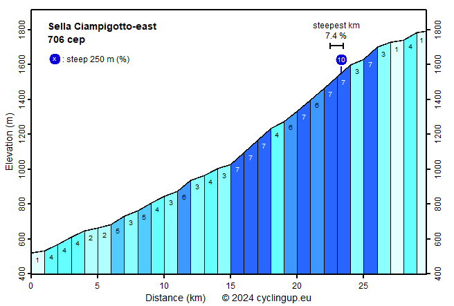
The ride from Ovaro through the Val Pesarina to the Sella Ciampigotto is long (30 kilometers) and as far as the slope is concerned little spectacular. The steepest part (often 7%) starts after 15 kilometers with two hairpin bends and ends eight kilometers further on, just after the turnoff to the Forcella Lavardêt. Just around the turnoff the steepest kilometer (7.5%) and the steepest stripe of 250 meters (10%) of the ride are found. Although really steep sections are missing, the climb is rewarding because, especially after the last village (Pesarîs), there is little traffic and because the tour is varied. Until Pesarîs the road passes through a series of villages. After that forests dominate. Only after the Sella di Razzo (1740 m), three kilometers before the end, the surrounding mountain peaks get clearly visible. For those, who consider continuing towards the Forcella Lavardêt and to Campolongo at the fork after 23 kilometers: this part of the SS465 is closed to traffic and has (in 2017) a catastrophic road surface.


Rijd op 22 maart deze prachtige tocht over de Veluwe, 75 of 125 kilometer vanuit Wageningen. Met veel hoogtemeters: resp. 550 en 970. Inschrijving
1K Ride
Rijd op 15 juni deze tocht met meer dan 1000 hoogtemeters; 80, 120 of 145 kilometer vanuit Oosterbeek. Inschrijving
Tour for Life
Rijdt deze zomer de unieke en klassieke 8-daagse wielrentocht van Noord-Italië naar Zuid-Nederland voor Artsen zonder Grenzen!

