Passo del Tonale-west

CyclingUp: Passo del Tonale-west

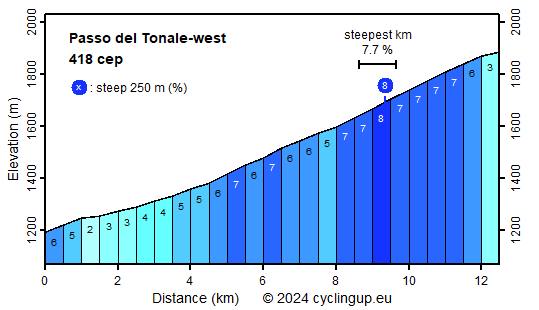
Climbing effort: 418 cep
Elevation meters: 691
Steepest kilometer: 7.7%
Steepest 250 m: 8%
Foot: 1192 m Top: 1883 m
Mean slope: 5.5%
Length: 12.5 km
From: Ponte di Legno
Road conditions (2023): average
Other race bikers: 5-10 per hour
Motor vehicles: 60-180 per hour
Scenery and road:
Restaurant or bar near top: yes
PHOTOS
E SIDE Download gpx

The Passo del Tonale is the highest point of the
road (SS42) connecting the regions of Lombardy,
west of the pass, and Trentino-South Tyrol,
east of the pass.
From the west the climb to the pass begins
at the turnoff to Ponte di Legno.
Here the SS42 gets steeper than before, though it should be added that
nowhere in the remaining 12.5 kilometers to the pass
the slope becomes really steep.
The steepest kilometer, beginning just under
9 kilometers after the start, tilts (7.7%).
In the last kilometer the gradient decreases.
The culmination point lies near a war memorial
that has been erected on the left side of the road.
Unfortunately, traffic including many trucks is quite busy.
As you cycle up, high peaks of the Adamello and Presanella groups
can be seen on the right side of the valley.
If you come from Edolo by bike,
then at the turnoff to Ponte di Legno you have already ridden 17 kilometers,
overcome 513 meters of altitude and collected 205
climb effort points.
In the first 9 kilometers of this approach the road
has a gradient of 4.0%, on average; the remaining 8 kilometers
are easier (average 1.7%).


Rijd op 22 maart deze prachtige tocht over de Veluwe, 75 of 125 kilometer vanuit Wageningen. Met veel hoogtemeters: resp. 550 en 970. Inschrijving
1K Ride
Rijd op 15 juni deze tocht met meer dan 1000 hoogtemeters; 80, 120 of 145 kilometer vanuit Oosterbeek. Inschrijving
Tour for Life
Rijdt deze zomer de unieke en klassieke 8-daagse wielrentocht van Noord-Italië naar Zuid-Nederland voor Artsen zonder Grenzen!

